

Aggregation Methodology for Communal Stormwater Management Retrofits on Private Property
Prepared By: Credit Valley Conservation (CVC), Scheckenberger and Associates Ltd., and WSP E&I Canada Ltd.
January 2024
Executive Summary
Implementation of traditional end of pipe stormwater management systems, while effective and practical in newer greenfield developments, tends to be more complex in the existing urbanized areas which constitute the majority of development in municipalities. Stormwater management (SWM) retrofits, i.e., applying SWM where there is none today, can achieve substantial benefits, including improved water quality and reductions in stormwater runoff.
While stormwater management retrofits can be applied in the public realm (i.e., road right-of-ways, parks), public lands typically only represent a small fraction of the urban land fabric, and there can be physical constraints to implementation. It can also be challenging and costly to acquire private land for dedicated stormwater management retrofits. Hence, the stormwater management approach outlined in this document investigates aggregating private lands under the Drainage Act for communal SWM retrofits. This approach (termed the “aggregation methodology”) represents an untapped opportunity to realize the co-benefits, both natural and social, of retroactively applied Low Impact Development (LID) Best Management Practices (BMPs). The aggregation approach examines collectives of multiple private (and sometimes public) properties from a SWM perspective. This takes advantage of economies of scale, multi-party cost-sharing and technical efficiencies to optimize the cost and functional benefits of LID BMPs.
There are many benefits to the application of LID BMPs as compared to conventional end-of-pipe SWM practices, notably, LID BMPs provide a more holistic approach to SWM, which better mimic pre-development conditions, resulting in improved water quantity and erosion control, better quality control, and overall water balance. Furthermore, LID BMPs, through their nature as source control measures, can frequently be more easily incorporated into retrofit type applications than conventional end of pipe SWM measures, given their diversity, scalability, and adaptability. LID BMPs can also be implemented either in the public realm (i.e., typically within roadway right-of-ways or public properties like parks), or private realm (residential, commercial, or industrial properties, depending on the application), or some combination thereof.
The main benefits of aggregation are largely economic in the form of capital cost-savings and reduced operations and maintenance costs. Groups of landowners can take advantage of economies of scale by sharing the costs of planning, design, construction, and on-going operations of communal source control systems.
There are also inherent reductions in land costs whereby the aggregation approach incorporates existing stormwater infrastructure on private property through partnership agreements. Unlike with conventional approaches, there is no need to pay full land costs needed to acquire land for conventional end-of-pipe stormwater management technologies.
The proposed economic and technical aspects of aggregation are expected to overcome the barriers to landowner uptake. The aggregation approach can provide municipalities with a viable stormwater management option for retrofitting existing developments under Class Environmental Assessments (EA).
There are various approaches to implement communal stormwater management and construct stormwater features. The available methods include:
- Easements
- Mutual Agreement Drains
- Condominium Act
- Drainage Act
Among others, Credit Valley Conservation (CVC) has advocated for the potential to leverage the Drainage Act as a tool to implement communal low impact development practices. The Drainage Act does not require municipalities (the typical owners and operators of stormwater management infrastructure) to purchase land or easements for access to private property. The Act also protects the constructed communal practices and guarantees right-of-access for municipalities. This legislative tool also ensures that benefits and responsibilities are allocated equitably, which includes not only the municipality (which is typically the case) but also the private landowners and other beneficiaries.
The methodology and approach to aggregation is hierarchal and has been aligned with the Municipal Engineer’s Association (MEA) Class Environmental Assessment (EA) planning process for public infrastructure (ref. MEA, 2015). In developing the various stages for this methodology and approach, consideration has been given to how municipalities and watershed managers define their priorities. These priorities focus on the severity and nature of the drainage and environmental problems they need to address. In select circumstances, private property aggregation may be the most efficient way to achieve policy priorities. Municipalities should evaluate retroactive stormwater management measures, including aggregation, alongside other more traditional forms of SWM (i.e., end-of-pipe solutions).
The aggregation methodology presented herein is based on four stages:
Stage I: Pre-Aggregation (Macro) “Establishment of Priority Areas”
Stage II: Aggregation Planning (Meso)
Stage III: Aggregation Design (Micro)
Stage IV: Post-Aggregation Implementation, Monitoring and Operations & Maintenance (O&M)
The following details the approach, information sources, and expected outcomes for each stage to assist users in applying the methodology to their specific community/area-of-interest. Each stage is accompanied by a series of steps to provide context and “check points” for users to ensure the outcomes are well supported in process. Not all stages or steps need to be followed in all settings, however, it is considered beneficial to establish the application of the aggregation methodology in a systematic and logical manner as outlined herein.
For context, when a municipality plans work to address identified SWM problems, it typically needs to have a basis for its decision making. For example, “why has it selected this area over others?” and “why/how has it determined that aggregation is the preferred solution?” Without answers to these questions and clear, traceable documentation, including records of consultation with stakeholders, members of the public, and others, it would possible to challenge the municipality’s recommendations and associated investment in those solutions. The Class EA process addresses these risks and allows municipalities to confidently plan their infrastructure.
That said, if a municipality has known, well documented drainage problems in a certain part of its community, and,
- if it initiates work in that area based on legacy data, and
- if that same municipality conducts a screening of feasible SWM solutions resulting in a recommendation of aggregation,
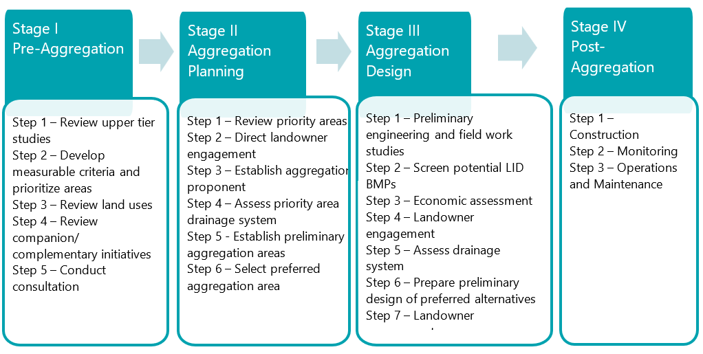
then it can reasonably be assumed that the main requirements of a Class EA will have been followed, hence supporting the community’s decision making. Figure 1 summarizes the stages and steps of the methodology.
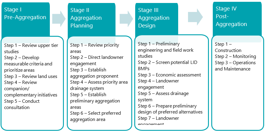
Figure 1. Summary of the stages and steps in the aggregation methodology.
We have also prepared a case study which examines how the aggregation methodology could be applied to an industrial, commercial, and institutional neighbourhood in the City of Mississauga. While initiated prior to and concurrently with the development of this methodology, some important lessons learned have resulted from the process. The case study, titled “Aggregation Methodology Case Study in Mississauga’s Southdown Neighbourhood”, is available on the STEP website.
Finally, Section 5 below gives a set of flow charts which outline the relationship between the stages and the associated steps described in Figure 1. Reference these flow charts when interpreting the associated description of stages and steps.
Table of Contents
- Introduction
- Background
- Methodology and Approach
- Conclusions/Next Steps
- Process Flow Charts
- References
- Publication Information
- STEP
- Acknowledgements
- Notice
1 Introduction
1.1 How to Use Document
The current version of this document is Version 1.0. Subsequent versions may be updated based on feedback.
Appendix A contains a glossary of terms to support readers of this document. All words that are in the glossary are in bolded text the first time they appear in the document. Please consult the glossary in Appendix A for detailed definitions.
This feasibility Study of the aggregation methodology was conducted to determine if it is both feasible and viable. In addition, we have published a case study which in part applied the aggregation methodology was initiated to assess the technical and financial feasibility of aggregation. Titled Southdown Case Study: Aggregating Private Properies for Communal Stormwater Management Retrofits it is available on the STEP website.
The stages and steps of the aggregation methodology are illustrated in Section 5 below through a series of process flow diagrams.
1.2 Objectives and Rationale
It has been well documented that impacts due to urbanization on stormwater runoff without proper management can lead to flood risks, degraded water quality, erosion of watercourses and altered water budget/cycle. To address these impacts, engineers have been advocating for stormwater management (SWM) for approximately five (5) decades in North America (see Section 2.1).
One of the barriers to fully realizing a functional and healthy ecosystem, which is often founded on water resources, relates to the legacy of historical impacts from existing developed lands without stormwater management which discharge untreated and unmanaged stormwater. Stormwater management retrofits (i.e., applying stormwater management where there is none today) can achieve substantial benefits including improved water quality and reductions in stormwater runoff (peaks and volume). From a municipal standpoint, end-of-pipe stormwater management retrofits can be applied in the public realm (i.e., road right-of-way, municipal properties) to provide a level of treatment. However, in urban areas without stormwater management, there are often insufficient suitable public lands available for end-of-pipe retrofits. In established urban areas, existing infrastructure already crowds the road right-of-way, leaving little space for stormwater management retrofits. Similarly parks and other public lands are often constrained by existing valued uses. An alternative is to explore the application of stormwater management retrofits on private lands; however, the key issue has been that there are limited incentives to apply stormwater management retroactively to these existing areas. The result has been virtually no uptake of voluntary, private property retrofits. Stormwater treatment along roadways and the associated efficacy can often be limited and constrained by infrastructure, existing land uses and topography, resulting in the need for better and more effective plans. Further, acquiring private land for dedicated stormwater management retrofits, and the associated requirements of re-working drainage networks to drain towards these lands, can be very costly and usually is not preferred. With the advent of stormwater utilities/municipal stormwater rates over the past decade, Ontario has seen an emerging opportunity for providing economic incentives through stormwater rate credits to the private sector, in applying on lot stormwater management practices retroactively. An issue though has been the long payback periods which have not sufficiently incentivized the private sector.
The foregoing has led to the philosophy/thesis that if co-benefits of retroactively applied Low Impact Development Best Management Practices (LID BMPs) are fully valued, there may be a broader cross-sectoral rationale for implementation, including those benefits attributable to the social, economic, and natural environments. Notwithstanding, the monetization of these benefits (often referred to as non-market benefits) can be complex and, in some instances, difficult to support or realize. Furthermore, the benefits attributable to individual property-by-property retrofits can also be functionally complex to realize and often difficult to universally implement, due to physical or operational constraints.
As a result, CVC has advocated for a process of “aggregation” which involves collectives of multiple private (and sometimes public) properties which can then take advantage of economies of scale, multi-party cost-sharing and technical efficiencies, due to attributes associated with land use, topography, processes, etc., in order to optimize the cost and functional benefits of LID BMPs (ref. CVC, 2017; CVC, 2018a; CVC, 2021).
Due to this relatively novel approach of addressing stormwater management through aggregation, and the lack of historical precedence, Credit Valley Conservation and its partners have prepared this document to outline a methodology that can facilitate the planning, design, implementation, operations and maintenance, and financing of an aggregation approach to stormwater management. This Guidance Document is intended to provide municipalities and their partners/stakeholders with an approach to conducting a top-down methodology to addressing runoff problems (quality and quantity), which considers aggregation as a viable alternative approach to stormwater management. Given that municipalities must plan their infrastructure needs and renewal through the Environmental Assessment Act, with specific guidance from the Municipal Engineer’s Association (MEA) Class Environmental Assessment (EA) (MCEA, 2015), the aggregation methodology outlined herein has recognized the role and principles of Class EA planning, in order to provide a consistent municipal context. Furthermore, the Drainage Act has been identified as a potential instrument by which multiple property owners can collaborate through a democratic, bottom-up process to establish a communal drainage system. Further details on the foregoing are highlighted herein.
1.3 Purpose of Document
This document lays out a hierarchal methodology which outlines the “stages” and “steps” to the aggregation methodology, along with the associated role of municipal proponents, in the process of ultimately establishing targeted areas within a community, where aggregation for stormwater management is potentially appropriate, and how to go about these forms of assessment. The document acknowledges that this process is multi-tiered and staged, with a recognition of various scales including watershed, district/neighbourhood, and local properties. This document is intended to offer a structure for municipal proponents, noting their respective roles at the various stages accordingly.
In the broader context, it needs to be acknowledged that aggregation is one potential element of an integrated solution to address stormwater quantity and quality issues, in addition to other options in the SWM toolkit (conveyance upgrades, storage systems/ponds, diversions etc.). It is however important to consider aggregating private properties for SWM, applying LID BMPs, alongside more traditional methods on public property. To this end, it is the municipalities who will have the central role in realizing comprehensive SWM solutions, including Aggregation, principally by evaluating aggregated LID BMP retrofits as a potentially viable alternative, through the Municipal Class Environmental Assessment (EA) process.
This guidance document, which outlines the methodology to plan and implement communal stormwater management, is part of a suite of documents that examine related topics. Figure 2 summarizes the key documents produced to date as part of a CVC-led feasibility study that is examining the technical and financial feasibility of communal stormwater retrofits. For more information about the project and how to access to the reports outlined here, please visit the project website: https://sustainabletechnologies.ca/home/urban-runoff-green-infrastructure/aggregated-communal-approaches-to-gi-implementation/
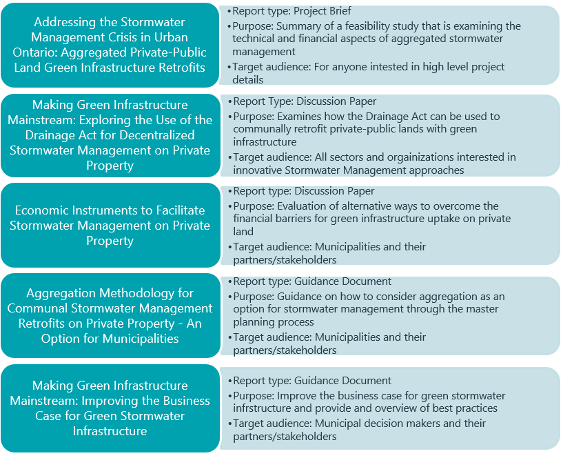
Figure 2. Summary of CVC’s communal green infrastructure documents.
2 Background
2.1 History of Stormwater Management in Canada
Stormwater Management (SWM) in the 1970’s and 1980’s focused primarily on peak flow control, often referred to as ‘peak shaving’, with minimal regard to water quality and volumetric management needs. The second generation of stormwater management (circa 1990’s) then shifted to a more comprehensive form of stormwater treatment which included both quantity and quality management, although the primary form of quality treatment tended to focus on end-of-pipe measures (typically wet ponds, wetlands and oil and grit separators). Subsequent generations (2000’s+) of stormwater management planning and design, shifted to a further integrated approach to runoff management by also considering volumetric controls to not only manage peak flows, but also runoff volume for most storm events. This latter generation of stormwater management then included a broad suite of practices more focused on controlling runoff at source, often referred to as Low Impact Development (LID) Best Management Practices (BMPs).This progression of managing the runoff impacts due to urbanization through contemporary stormwater management has in many ways shifted the responsibility from strictly the public sector to a combined responsibility of the public and private sectors, whereby many proposed SWM practices intended to manage water at source, can often be located on private property. A schematic of the evolution of urban stormwater management is provided in Figure 3 below.
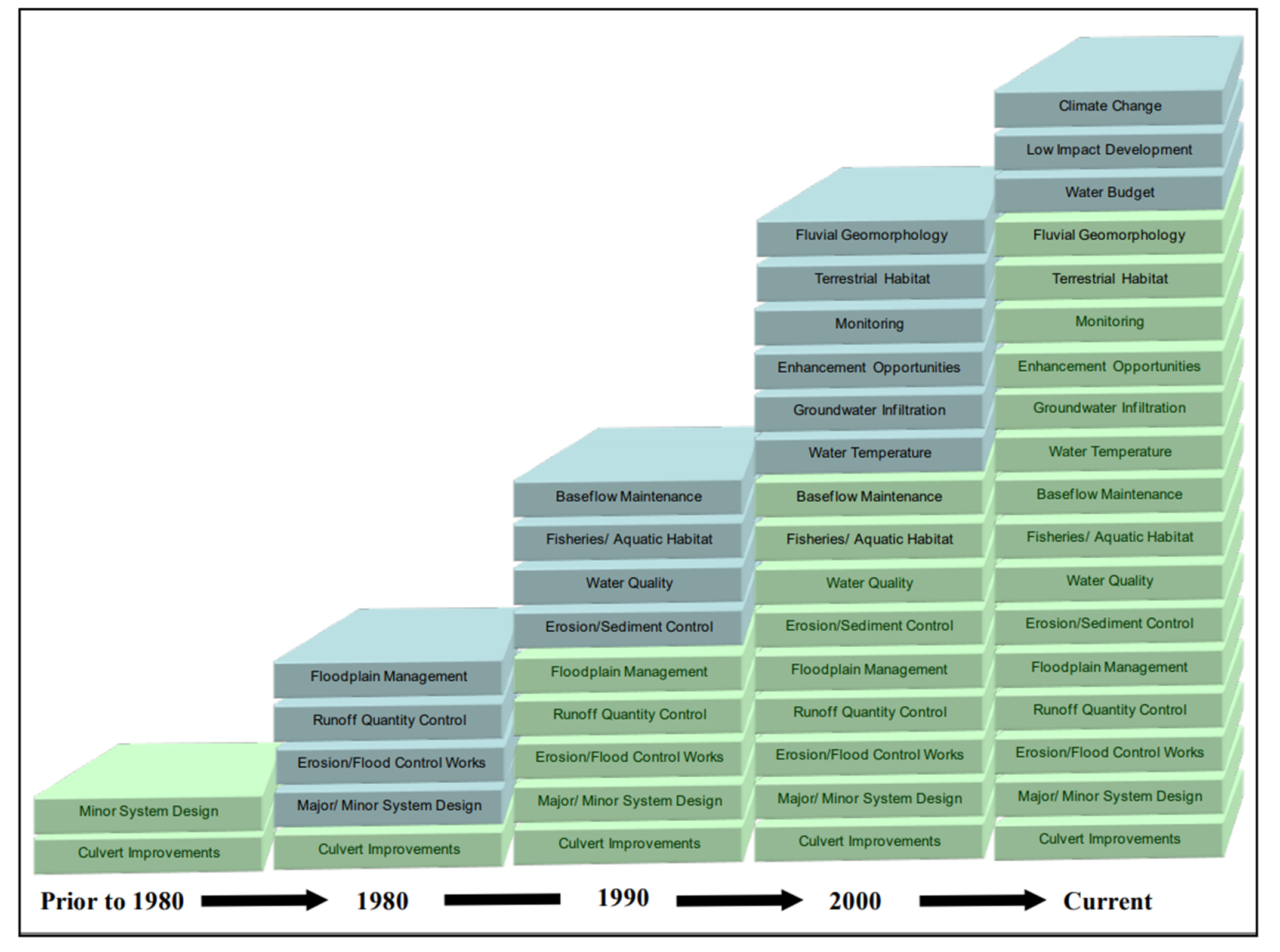
Figure 3. Succession of stormwater management techniques since 1980 (adapted from MOEE, 1993).
The majority of urbanization in Southern Ontario took place before the advent of modern stormwater management which, in its earliest forms, was implemented in the mid-1970’s. Since that time, however, most greenfield development has had some form of stormwater management, depending on the era of development. More recent Provincial and Municipal growth plans have shifted the priority of growth from expansion (greenfield) to be more inwardly focused within communities through infill and intensification (I/I) plans based on existing urban limits. Typically, the latter form of urban development already has urban services (roads, water, wastewater, stormwater); however, due to the intensified population and land coverage (imperviousness), services need to be upgraded which then provides an opportunity of applying retroactive stormwater management where none existed previously. It needs to be acknowledged that in most communities, the largest proportion of urban development has no contemporary stormwater management or if it does, it would most likely not meet current standards. The type of stormwater management can be reasonably assumed based on when development occurred, see Figure 3.
2.2 Low Impact Development Best Management Practices
Low Impact Development Best Management Practices (BMPs) refer to a broad suite of stormwater management (SWM) control measures that generally focus on at-source control and incorporate filtration and/or infiltration techniques to mimic natural hydrologic processes. As such, LID BMPs are often used interchangeably with other related terms such as source controls or green infrastructure (GI). LID BMPs may involve multiple different systems and approaches and are frequently applied in series as part of a treatment train. A treatment train approach provides the benefits of redundancy and typically yields a greater overall SWM benefit, with respect to quantity, quality, erosion control and water balance. Although LID BMPs include numerous different techniques, typical practices include:
- Rainwater Harvesting and Downspout Disconnection
- Green Roofs and Blue Roofs
- Soakaway Pits, Infiltration Trenches and Chambers
- Bioretention areas
- Permeable Pavement
- Enhanced Grassed Swales, Bioswales and Dry Swales
- Perforated Pipe Systems/Exfiltration Trenches
- Stormwater tree trenches
- Engineered Products and Filter Media
There are numerous benefits to the application of LID BMPs as compared to conventional SWM practices, which generally involve “end of pipe” measures such as oil/grit separators, sub-surface storage chambers, or ponds (dry ponds, wet ponds, wetlands, etcetera). Overall, LID BMPs provide a more holistic approach to SWM, and better mimic pre-development conditions, resulting in improved water quantity and erosion control (increased infiltration, reduced/delayed peak flows, volume control), better quality control (increased treatment through filtration and uptake of contaminants through biological action), and overall water balance (increased infiltration and groundwater recharge, increased evapotranspiration).
LID BMPs, largely through their nature as source and conveyance control measures, can frequently be more easily incorporated into retrofit type applications than conventional end of pipe SWM measures, given their diversity, scalability, and adaptability. LID BMPs can also be implemented either in the public realm (i.e., typically within roadway right-of-ways or public properties like parks), or private realm (residential, commercial, or industrial properties, depending on the application), or some combination thereof. Many innovative water projects involving LID BMPs have been successfully implemented across the GTA on public and private lands, however despite their success they have failed to lead to wide scale adoption.
This guidance document is not intended to be a comprehensive guide to LID BMPs; numerous documents and guidelines already exist which provide greater detail and background to this subject. The reader is directed to key documents that are hyperlinked below in this regard, including:
- Assessment of Life Cycle Costs for Low Impact Development Stormwater Management Practices (STEP, 2019) – Link to project website
- LID BMP Retrofit Series
- Road Retrofits (CVC, 2014) – Link to report
- Business & Multi-Residential Retrofits (CVC, 2013) – Link to report
- Public Lands Retrofits (CVC, 2014) – Link to report
- Residential Retrofits (CVC, 2015) – Link to report
- Low Impact Development Stormwater Management Planning and Design Guide (wiki.sustainabletechnologies.ca)
- Low Impact Development Construction Guide (CVC, 2012) – link to report
- Low Impact Development Stormwater Inspection and Maintenance Guide (TRCA, 2016) – link to report
Some of the specific barriers to wide scale adoption of LID BMPs have been explored through market research studies undertaken by the Cities of Mississauga (Freeman & Associates, 2008) and Kitchener (Aquafor Beech Ltd. and Freeman & Associates, 2015). These studies identified the primary barriers to the wide-scale use of LID BMPs to be as follows:
- Private Sector
- Capital Cost of individual Lot by lot LID retrofits can be high.
- Stormwater credits (see section 2.6) have little impact on reducing payback periods.
- No standard implementation framework for private landowners.
- Public Sector
- Most municipalities prefer public stormwater systems on public property.
- Lack of space on public land.
- Capital investment in LID BMPs is narrowly scoped and project based.
2.3 Potential Benefits of Aggregation
The potential benefits of aggregation fall into two categories; improved technical performance and economic efficiencies. Technical performance relates to enhanced drainage system effectiveness to address quality and quantity issues while economic efficiencies occur in the form of capital cost-savings and reduced operations and maintenance costs (life-cycle). If landowners collaborate on stormwater management, economies of scale will begin to emerge through the efficiencies gained by sharing of the planning, design, construction, and on-going operational costs for the source control system. It is anticipated that the following cost efficiencies can be attributed to aggregation projects for stormwater management, where one communal system is implemented, as opposed to multiple stormwater management projects completed through lot-by-lot retrofits:
- Engineering and pre-construction costs: one designer, one geotechnical report, one utility stakeout, one topographical survey, etc.
- Construction: savings on mobilization and demobilization, delivery of materials, leveraging bulk purchasing, etc.
- Administration: one set of permits, one point of contact for permitting.
- Operation and maintenance: the same crew can service multiple properties, rather than having multiple crews service each property’s system independently.
While a larger system generally entails a higher cost, the cost per unit of stormwater volume treated (m3) and per landowner, is expected to be proportionally lower with communal systems. It is proposed that equitable cost sharing for the stormwater management system be completed between the public and private properties based on the respective benefit of the subject drainage works.
The aggregation approach involves implementing stormwater infrastructure on private property through partnership agreements, therefore full land costs for conventional stormwater management technologies, such as end-of-pipe facilities may be avoided or minimized, further reducing costs.
As noted above, it is anticipated that communal stormwater management on private lands can offer improved performance compared to conventional approaches. End of pipe pond facilities predominately focus on peak flow control and total suspended solid (TSS) removal, however additional water quantity and quality improvements can be provided by private side infrastructure. Through source and conveyance controls, private communal systems have the added potential for infiltration allowing for runoff reduction in addition to flood control. For water quality, source and conveyance controls offer the opportunity to address other parameters of concern in addition to TSS. Specifically, source controls can prevent thermal enrichment of stormwater runoff before it enters local waterways. Another important distinction to make between conventional and private communal LID practices, is that with LID BMPs there are many co-benefits such as urban heat island reduction, urban tree canopy creation, improved biodiversity, carbon sequestration, traffic calming, energy savings, etc.
Additionally, with aggregation the stormwater solution is not confined to a single property within its property limits, therefore technical elements of the project (i.e., the design) can be site optimized for performance, such as locating infiltration practices where the soils are most suitable, to further take advantage of technical (functional) and cost efficiencies.
The proposed economic and technical aspects of aggregation are expected to overcome the barriers to landowner uptake and provide municipalities a viable option for retrofitting existing developments which have no SWM to consider in Class EA’s. Although it is anticipated that this guide will be a municipal-led process, the benefits to the private landowner should also be considered. For more a more detailed discussion on the concepts of aggregation and the potential benefits, the reader should consult the two Discussion Papers described in Figure 2 of this report.
2.4 Implementation of Aggregated Stormwater Systems on Private Property
There are various approaches for aggregating private/public property to implement and construct stormwater practices. This section provides an overview of the available methods and highlights some notable advantages and/or disadvantages.
Easements
Easements approved through the Planning Act can secure the right to enter onto private property to inspect and to maintain stormwater infrastructure. Establishing individual easements on a property-by-property basis for stormwater management practices can be costly however since a survey conducted by an Ontario Land Surveyor and registration of the easement on title would both be required. Since easements are registered on title, they can have the potential to devalue property worth, as it may restrict the use of the encumbered land.
Easements generally have no provisions to recover construction or maintenance expenses from the private landowner. In the case of easements, it can also be difficult to protect the asset on private property from being damaged and/or altered. Also, easements usually do not contain operational information such as instructions for maintenance (frequency, how to maintain, etc.).
Mutual Agreement Drains
A mutual agreement drain may be created where landowners agree to an approach for resolving drainage issues and the sharing of costs for construction, maintenance and future improvements. A mutual agreement drain offers a low-cost option to resolve typically small drainage issues involving few landowners (whether established through a plan of subdivision or site plan) and possibly a municipal roadway. Ontario Ministry of Agriculture, Food and Rural Affairs (OMAFRA) has a form that can be used to establish mutual agreement drains. When the municipality is involved, it typically takes on the responsibility of drafting the agreement content. Reaching drainage agreements and consensus between three or more properties however can be challenging.
Mutual agreement drains are not binding to subsequent property owners unless they are registered on title. To register a mutual agreement drain document on title will require the assistance of a lawyer and/or Ontario Land Surveyor familiar with the Ontario Land Registry system.
Mutual agreements for drainage do not inherently provide a process for future maintenance when needed or provide for access to properties when maintenance is required. Agreement drains also do not necessarily require easements to be established along the route of the drain. Easements may be recommended in order to ensure access to affected properties for future maintenance. An Ontario Land Surveyor would be required to establish an easement along the route of a drain and to have this easement registered on title along with the mutual agreement document.
Condominium Act
Communal private property stormwater management is possible under the Condominium Act. It allows condominium owners to aggregate resources by sharing in the costs for construction and for the maintenance of the subject drainage works. Although the Condominium Act may allow for cost sharing amongst owners, drainage works are to be within a single condominium property. The Condominium Act is not structured to readily accommodate the pooling of stormwater resources across multiple property boundaries, nor is it well-suited to the implementation of trans-boundary drainage features. The Condominium Act only allows for cooperation amongst multiple owners of the same property (e.g., a condominium board), and not multiple-property aggregation.
The Drainage Act
The Drainage Act is an Ontario Statute that provides a process for the construction and maintenance of communal drainage works on private and public property. The Drainage Act helps to overcome some of the barriers to LID uptake discussed earlier (high costs, long payback period, lack of space, lack of implementation framework). The cost of construction and maintenance of all communal drainage works is assessed to all affected lands and roads. Drainage Act assessments apply to the lands and not the individual property owner, therefore if land changes ownership, the new owners would be assessed costs accordingly. Another advantage of the Drainage Act is that power of land entry is granted for municipal personnel without the need for easements, to inspect and maintain the drainage infrastructure. Additional details on applying the Drainage Act process for aggregated systems is provided in Section 2.5.
2.5 Application of the Drainage Act
The Definition in Section 1 of the Drainage Act states that a drainage work:
- Includes a drain constructed by any means, including the improving of a natural watercourse, and
- Includes works necessary to regulate the water table or water level within or on any lands or to regulate the level of the waters of a drain, reservoir, lake or pond, and includes a dam, embankment, wall, protective works or any combination thereof.
The Drainage Act traces its roots to an act put in place in 1835 in Upper Canada to regulate line fences and watercourses. Issues related to drainage of land and property lines were a problem for settlers in the 1800’s.
Today these same issues still cause problems between neighbours. The Drainage Act process is commonly implemented in rural Ontario for drainage issues on agricultural land. However, there are many examples where the Drainage Act process has been used for drainage issues between neighbours on private and/or public lands in urban settings (Table 1).
Table 1. Urban Drainage Act Case Studies.
| Urban Drain | Location in Ontario | Drain Type | Drainage Issues | Petitioner |
| Mindemoya Drain | Manitoulin | New storm drain | Historically, street drainage in the village of Mindemoya had discharged to a surface watercourse that crossed private property. The municipality wished to improve several streets and required a proper outlet for new storm drains. | The Road Superintendent submitted a petition for improved drainage outlet for the streets to be reconstructed. |
| Villages of Long Point Bay | Port Rowan | New storm drain | A proposed residential development would nearly double the town’s population. A stipulation for this development in the town was that all stormwater works be implemented under the Drainage Act to provided long-term cost recovery for operations and maintenance | The developer submitted a petition |
| Ospringe Drain | Erin | New storm drain and legal outlet needed | A proposed residential development required a sufficient outlet. The Town of Erin requested that a municipal drain be created to provide adequate capacity to convey the storm drainage from the subdivision | The developer submitted a petition |
| Woodridge Drain | Wilmont | Existing drainage issues | Cultivated farmland drained toward residential lots and the external drainage was accounted for however the original lot grading plan was not working. | Residential property owners desired improved drainage outlet and petitioned |
| Balsam Street Drain | Welland | Existing drainage issues | An existing rear yard swale had been impacted by the construction of rear yard fencing and other post-development activities | Residential property owners desired improved drainage outlet and petitioned |
| Gravel Ridge Drain | Kitchener | Legal outlet needed | The drain addressed the issue of a legal outlet for the discharge from a storm water management facility for a new residential development. | The developer was not able to negotiate an agreement for a drainage easement with the downstream owners and submitted a petition. |
A drainage work under the Drainage Act is initiated by a petition as outlined in Section 4 of the Drainage Act. A petition for improved drainage signed by a landowner or group of landowners is submitted to their municipality. Section 4(1)(c) of the Act notes that where drainage works are required for a road or part thereof, a petition may be submitted by the engineer, road superintendent or person having jurisdiction over such road or part.
The municipality then provides a venue for the process outlined in the Drainage Act. Council appoints an engineer to prepare a report on the petition for improved drainage. The appointed engineer then holds an on-site meeting, and a site examination and survey, to determine the work required to provide the improved drainage requested by the petitioners.
Section 8 of the Drainage Act states that the engineer’s report resulting from this process shall include:
- A watershed plan, profiles and specifications for the proposed drainage works;
- Allowances to owners affected by the construction of the drainage works;
- Total estimated cost of the work;
- Schedule of assessment to levy the total estimate cost to all affected lands and roads using benefit assessment and outlet liability assessment and other provisions for assessment, as outlined in Sections 21 to 28 of the Drainage Act;
- Provisions for future maintenance of the drain once constructed.
When filed with the municipality, the Engineer’s Report follows the process outlined in the Drainage Act ending with the municipal council passing a bylaw to adopt the engineer’s report and then undertaking the construction of the drainage works in the Report.
In the bylaw adoption process, there are a number of opportunities for an appeal by the affected and assessed lands and roads. The Court of Revision, which is set up by the municipality, addresses appeals against the schedule of assessment in the report.
The Drainage Tribunal (independent panel appointed by the Ministry of Agriculture, Food and Rural Affairs) deals with appeals related to the design of the recommended drainage works and appeals on assessment, where the appellant was not satisfied with the decision of the Court of Revision. If an affected owner is not satisfied that the municipality and/or the engineer has properly followed the legal requirements of the Drainage Act, then an appeal can be addressed to the Drainage Referee for resolution.
After a drain is constructed, the municipality levies the final cost of the project in accordance with the schedule of assessment for construction in the report.
Section 74 of the Drainage Act requires the municipality to maintain the drain in the future to the specifications outlined in the Report. Cost of maintenance is levied to the affected (benefitting) lands and roads, as outlined in the schedule of assessment for future maintenance in the report.
Recently in Ontario, many municipalities have established stormwater rates through stormwater utilities to plan, design, construct and maintain municipal drainage infrastructure. Municipalities that have used the Drainage Act for drainage improvements, have in essence established a stormwater rate (maintenance schedule in the report) and stormwater utility (Drainage Superintendent as defined in the Act) in place for the period of the works. There are many examples of when the Drainage Act has been used in urban areas in new and existing developments for stormwater management. Refer to the case studies in Table 1.
Among others, CVC has advocated for the potential to leverage the Drainage Act as a tool to implement aggregated (shared) low impact development practices. For more information the reader is directed to the position paper, titled “The Drainage Act as a Tool to Facilitate the Aggregation and Wide-Scale Implementation of Green, Low Impact Drainage Infrastructure on Private Property” (CVC, 2018a). The Drainage Act helps to overcome some of the barriers to aggregation discussed earlier, including:
- Cost savings thorough economies of scale for the planning, design, construction, and on-going operational costs for source control systems. While a larger system generally entails a higher cost, the cost per unit of stormwater volume treated, is expected to be proportionally lower with communal systems.
- The cost of construction and maintenance of communal drainage works is assessed to all affected (benefiting) lands and roads.
- Drainage Act assessments apply to the lands and not the individual property owner. Therefore, if the land changes ownership, the new owners would be assessed costs accordingly.
- The Drainage Act does not require municipalities (the typical owners and operators of stormwater management infrastructure) to purchase land or easements for access to private property. The Drainage Act grants land entry for municipal personnel to inspect and maintain the drainage infrastructure.
The Ministry of Environment Conservation and Parks (MECP) modernized Ontario’s Environmental Compliance Approval (ECA) process for low-risk municipal sewage works by initiating a Consolidated Linear Infrastructure permissions approach in 2020. It allows for works to be pre-authorized as per the conditions set out in the ECA without the need for a separate approval.
MECP also recognizes the potential of using the Drainage Act to include stormwater management on private property (see figure below) as part of the treatment train and as a mechanism to protect infrastructure. In Schedule D of the proposed linear infrastructure ECA template, it indicates that when necessary to use privately owned stormwater works in the treatment train to meet the given criteria, the municipality requires a legal instrument to have the right to access, operate and maintain the infrastructure. MECP notes that examples of legal instruments will be included in a future document that will accompany the ECA template and will include the Drainage Act.

2.6 Stormwater Rates/Utilities
In Ontario, the responsibility for the management of stormwater management (SWM) systems is typically borne by municipalities (lower tier in the case of two-tier municipalities). This responsibility involves not only review and approvals of new practices (both those to support new development as well as retrofit practices), but also the ongoing inspection and operation and maintenance of existing SWM practices, including conveyance features (swales, channels, storm sewers, etcetera), as well as SWM treatment features (oil/grit separators, storage chambers, ponds, LID BMPs, etcetera). As the amount of development and stormwater infrastructure continues to expand, as existing infrastructure continues to age and require increased maintenance, and as regulation and public scrutiny of SWM increases, municipalities have been challenged to adequately fund and finance required works. Funding is typically further complicated by conventional budget practices, which allocate stormwater funding as a portion of the water/wastewater charge, which is a fundamentally different infrastructure service than stormwater.
In recent years, an increasing number of municipalities have implemented stormwater rates, or stormwater utilities, to address municipal stormwater funding concerns. Stormwater utilities have been implemented or are being studied in numerous municipalities in Southern Ontario, including the City of Mississauga, City of Kitchener, City of Ottawa, City of Cambridge, City of Windsor, City of Vaughan, City of Markham, City of Brampton, City of Hamilton, and others.
Numerous background documents are available which provide relevant information on stormwater utilities, [see “Urban Stormwater Fees: How to Pay for What We Need” (Environmental Commissioner of Ontario, 2016)]. In general terms, a stormwater utility is a dedicated source of funding to support municipal stormwater works. A stormwater fee is typically charged to area residents and businesses through utility bills or part of property taxes, based on the area of a property, and specifically the amount of impervious (hard surface) coverage. In many cases, the stormwater utilities provide a financial incentive to property owners for implementing on site stormwater management controls; stormwater charges are typically reduced based on the amount of on-site controls, as compared to the full charge applied to a property without any such controls. Notwithstanding, even with rebate/credit programs on the stormwater rate, uptake has been low for private landowners to voluntarily retrofit their property with LID BMPs. More details on stormwater utility and rebate/credit programs are provided in the discussion paper titled Economic Instruments to Facilitate Stormwater Management on Private Property (CVC, 2018b). See Figure 2 of this report for a link to the discussion paper.
Did you know that the City of Philadelphia found it was up to three times less costly to retrofit privately owned lands with green infrastructure compared to projects on publicly owned land and offer a competitive capital funding program (NRDC, 2015)? The Philadelphia Water Department offers an aggressive capital incentive program for private non-residential properties. The grants awarded ranged from $70,000 to $580,000 per greened acre (Philadelphia, 2022).
2.7 Additional Programs and Incentives
In some cases, there may be additional programs or incentives to further support stormwater management implementation and operations. For instance, water use programs are one potential support mechanism for LID BMP aggregation. Many municipalities provide financial incentives to both homeowners and private business owners to reduce their water usage. Within the Region of Peel, the Water Smart Peel program promotes water conservation. As part of this program, the region offers rebates for businesses to upgrade to water-efficient fixtures. The region also offers free assessments of water usage (including process and irrigation systems) and provides rebates (in addition to the longer-term savings associated with reduced water consumption) for businesses which incorporate water saving measures. Aggregated LID BMPs which involve water recycling and re-use and thereby reduce the need for potable water consumption (such as rainwater harvesting and cisterns) could potentially benefit from these additional financial incentive programs.
Further, inflow/infiltration reduction programs may also provide incentives and support for SWM implementation and operations. These programs aim to reduce extraneous inflow and infiltration to the wastewater (sanitary) system. Inflow and infiltration results in reduced conveyance capacity, which in significant amounts may trigger sewer backups and basement flooding. In addition, excess inflow/infiltration can lead to additional and unnecessary wastewater treatment costs at treatment facilities. As such, many municipal authorities have incentive programs to reduce inflow/infiltration, including disconnection of downspouts, weeping tiles and storm lateral connections from the sanitary sewer system. Aggregated LID BMPs may similarly be eligible for such incentive programs, by re-directing or disconnecting direct sources of stormwater inflows, as well as reducing surface flooding or ponding above sanitary maintenance holes (i.e., through the application of infiltration chambers, blue roofs, rainwater harvesting, infiltration trenches, bioswales, etc.). Notwithstanding, it is important to acknowledge that there may be circumstances where private drainage (roof leaders, sump pumps, foundation drains etc.) adversely contributes to inflow/infiltration (I/I) to the sanitary system, which necessarily requires careful planning through an integrated stormwater management plan.
In addition to the preceding, there may also be funding opportunities through various environmental initiative programs. These programs may be one-time programs or perpetual and may be driven by stakeholder groups or non-governmental organizations (NGOs), or various upper levels of government (Provincial, Federal). Examples include call for proposals in 2021 from the Federation of Canadian Municipalities (FCM) which offers a Green Municipal Fund, the Province of Ontario’s Community Environment Fund, and the federal government’s Environmental Damages Fund. These programs may provide an additional financial incentive for the implementation and operations of LID BMP aggregation.
3 Methodology and Approach
As noted in Section 1, the methodology and approach to aggregation is inherently hierarchal and, to be effective, it needs to be aligned with established public processes, like the MEA Class EA planning process for public infrastructure (ref. MEA, 2015). In developing the various stages for this methodology, we considered how municipalities and watershed managers define their priorities. They typically rank priority areas based on the severity and nature of the drainage and environmental problems they are intending to address, by way of stormwater management measures including LID BMP aggregation, along with other more traditional forms of end-of-pipe SWM. Specifically, it needs to be acknowledged in the planning and decision-making processes that aggregation is not the sole solution to urban stormwater runoff problems; as noted, the methodology’s stages have embraced the consideration of broader solutions in the framework of the Environmental Assessment Act, through the MEA Class Environmental Assessment (MEA, 2015). Also, given that financing the implementation of an aggregation solution is only one of many elements in the process, the use of the Drainage Act (or the adoption of the various Drainage Act steps) has been advanced as a possible vehicle for financing and apportioning costs, but not the sole process, as other alternatives are also available.
The following provides a description of the four stages established for the aggregation methodology, namely:
Stage I: Pre-Aggregation (Macro) “Establishment of Priority Areas”
Stage II: Aggregation Planning (Meso)
Stage III: Aggregation Design (Micro)
Stage IV: Post-Aggregation Implementation, Monitoring and O&M
For the various stages, the approach, information sources, and expected outcomes are detailed to assist users in applying the methodology to their specific community/area-of-interest. The steps associated with each stage are not intended to be highly prescriptive, however, have been presented logically under each stage, to provide context and “check points” for users to ensure the outcomes are well supported in process. Inherently, not all stages or steps need to be followed; however, it is considered beneficial to establish the application of aggregation in a systematic and logical manner as outlined herein. For context, when a municipality plans work(s) to address identified problems, it typically needs to have a basis for its decision making – for instance “why has it selected this area over others?” and “why/how has it determined that aggregation is the preferred solution?”. Without answers to these questions and clear/traceable documentation, including records of consultation with public and stakeholders, members of the public and others would be able to challenge the municipality’s recommendations and associated investment in those solutions. The Class EA process addresses these risks and inherently allows municipalities to confidently plan their infrastructure. That said, if a municipality has known and well documented drainage problems in a certain part of its community, and if it initiates work in that area based on legacy data, and if that same municipality conducts a screening of feasible SWM solutions resulting in a recommendation of aggregation, it can reasonably be assumed that the main requirements of a Class EA will have been followed, hence supporting the community’s decision making. Figure 4 summarizes stages and steps of the methodology.
ALT TEXT Figure 4. Summary of the stages and steps in the aggregation methodology.
To assist users, sections six through thirteen contain a case study in the City of Mississauga. While initiated prior to and concurrently with the development of this methodology, some important lessons learned have resulted from the subject project execution, which have been incorporated into the discussion to assist users.
Section 13 offers a stage-by-stage and step-by-step set of flow charts which, in abbreviated form, outline the relationship between stages and the associated steps being considered for each stage of the aggregation process. These flow charts should be referenced when interpreting the associated description of stages and steps.
3.1 Stage I: Pre-Aggregation (Macro; Establishment of Priority Areas)
For public entities to act fairly and consistently in executing their mandate related to public infrastructure and services (specific to drainage and related environment), it is imperative to have a systematic and transparent process which establishes priorities based on a robust framework. The application of aggregation to problems is no different than any other municipally, taxpayer supported works.
As such, the intent of this stage of the Methodology is to systematically define the priority areas in the subject community/watershed which may benefit from the application of aggregation. A summary of the purpose and steps included in Stage I, Pre-Aggregation are summarized in
Figure 5. To elaborate, this stage is intended to define where there are urban drainage problems in the existing developed community, specific to locations with no stormwater management or dated/underperforming stormwater management infrastructure, which can potentially benefit from aggregation. In defining these priority areas (PA), it is necessary to consider where the nature of the problems and the land uses align, with the inherent understanding that aggregation does not solve all of an area’s problems and recognizing that source controls are typically most appropriate for the management of smaller runoff volumes.
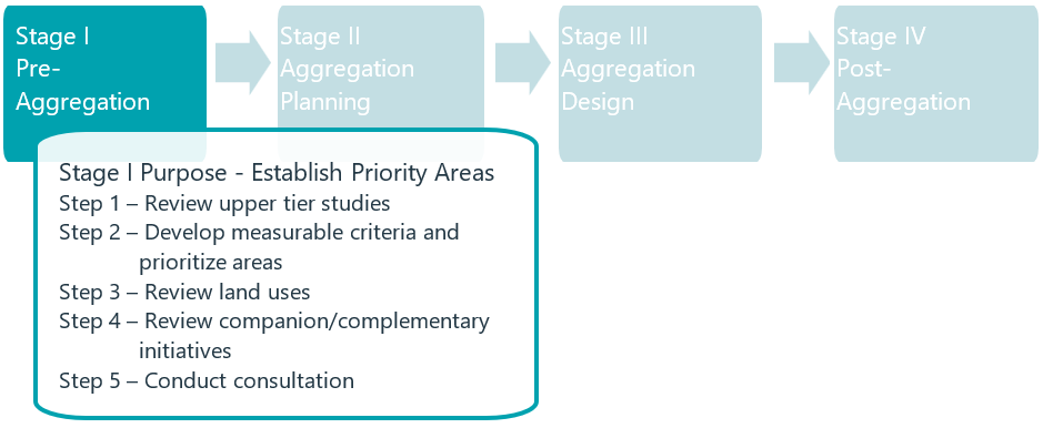
Figure 5. Summary of Stage I, purpose and steps.
Due to the community-wide, watershed scale, nature of this stage one, it is considered most appropriate to have the municipality or conservation authority, or a suitable partnership, lead its execution.
The outcome of this stage will be a set of ranked priority areas, established through the application of measurable criteria, reviewed, and vetted by the public and other stakeholders. These priority areas can then be used in a direct and seamless manner by municipalities to plan future works through more structured processes (MEA Class EA), as part of subsequent stages of the methodology (Stage II and III). Furthermore, preliminary budget estimates for studies and capital works can be programmed by municipalities into short, medium, and long-term plans at this stage.
Step 1: Review Upper Tier Studies
Approach:
In order to develop an understanding of where in a community/watershed the application of aggregation makes most sense, it is required to broadly (and evenly) develop an understanding of the broad scale characterization of the study area, as well as where there are issues of concern, which can be potentially mitigated by aggregation. This step will require the collection of reporting, mapping and other data from the municipalities, conservation authority, and others, which provide information on the physical setting for the project, specifically topography, groundwater, bedrock, and soils. It should also encompass the social setting through land use patterns, intensification plans, community resources, and market research studies. The review should focus on flood risk zones, erosion susceptible areas, sensitive ecosystems, reduced low and base flows, pressure on the SWM system, absence of SWM, and historical impacts.
The foregoing will need to be distilled into a set of maps (GIS-based) using a structured layering system for subsequent screening (see Step 2). As this is a ‘desktop’ exercise, it will be important to acknowledge the following:
- Data currency (age)
- Methods
- Limitations
- Gaps
It is unlikely that any municipality will have uniformly robust information, hence users will need to use caution when interpreting data from different sources, methods, and eras. Future gap filling efforts can be used to harmonize or level the understanding of available data, to support study area characterization and issues determination.
Information Sources:
Broad-scale information is expected to be largely available in the following types of reporting and associated mapping:
- Watershed/Subwatershed Studies
- Sourced from Municipalities/Conservation Authorities
- Physical data on water system and sensitive resources
- Fluvial data related to flooding and erosion
- Water budget (base flows, groundwater, surface water)
- Master Drainage Plans (City-wide/Area specific)/Class EA’s
- Sourced from Municipalities (Upper Tier/Lower Tier)
- Data on infrastructure, environmental systems
- Pluvial flooding locations and extent
- Water quantity/quality issues
- Basement flooding
- CSO’s
- Official Plans/Secondary Plans/Tertiary Plans
- Existing land uses
- Proposed future land uses
- Greenfield
- Intensification/Infill
- Policies
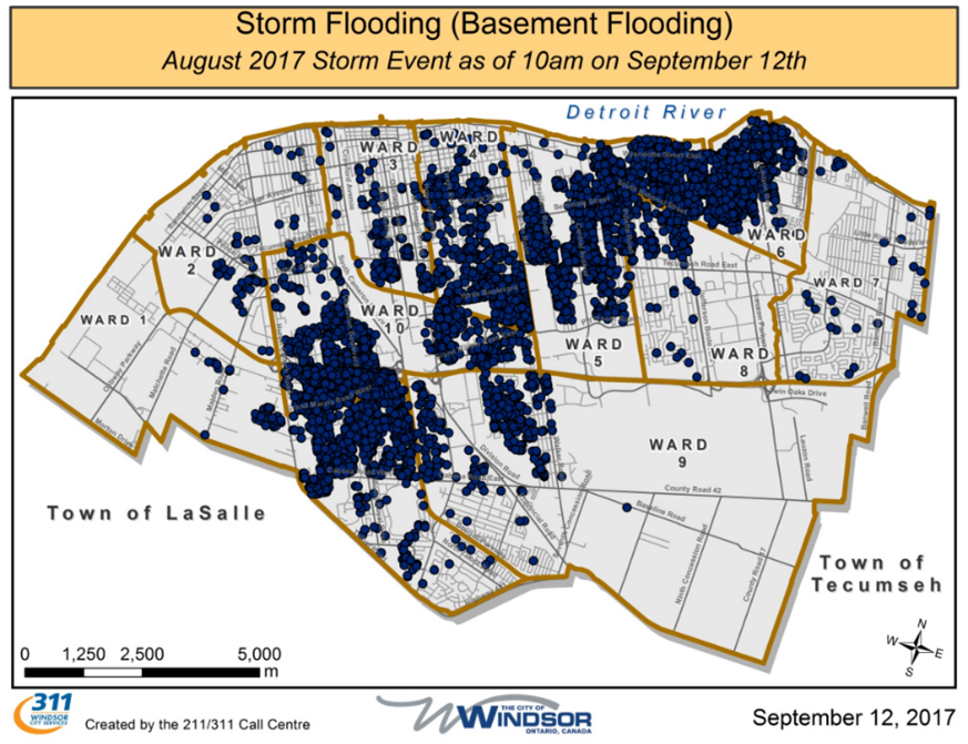
Call data information from 311 flooding reports collected by municipalities can be mapped to show vulnerable areas that could be prioritized for Aggregation. City of Windsor mapped calls into 311 for basement flooding due to a 220+ mm rain event that occurred August 28 and 29 in 2017 (City of Windsor, 2017). This is valuable documentation to support municipal decision making.
Outcomes:
As noted, this step will provide desktop information related to the Broad-Scale characterization of the Municipality/Watershed offering relevant map-based data on the:
- Physical environment
- Natural environment
- Social environment
Furthermore, available data, premised on various technical studies of drainage system performance (natural and man-made) and related issues, which may be potentially addressed through aggregation, will need to be summarized into thematic mapping built around logical drainage units, as follow:
- Watershed
- Subwatershed
- Sub Basins
- Local networks (neighbourhoods)
The issues should be appropriately layered by drainage unit and categorized as quantity and/or quality based.
Supporting documentation should summarize the sources and quality of information, known limitations, level of interpretation, as well as data gaps and recommended follow-up gap filling requirements (as necessary).
Step 2: Develop Measurable Criteria/Prioritize Areas
Approach:
Step 1 will provide an understanding of the physical, natural, and social environment along with a broad-based summary of drainage-based issues. Notwithstanding, the information as presented will not have been ranked or prioritized for action. Therefore, the focus of this step will be to develop a robust and supportable set of measurable criteria to distinguish between the varying characteristics across the community/watershed and the severity of the respective issues. The intent will be to establish priority areas (potentially conducive to the application of aggregation) through a weighted application of criteria using GIS-based mapping techniques.
Information Sources:
Most of the required information will have been derived through Step 1. However, given that the weighting (valuation) of the respective criteria will need to be robust and supportable, it is expected that municipal and agency (CA and others) engagement will be required to offer feedback on the selected criteria and their relative weighting. It is acknowledged that some criteria will be more easily quantified than others, hence some level of interpretation will be required to facilitate a fair and balanced application to the community/watershed-based dataset.
Outcomes:
The various characterization factors and area-wide issues (quantity and quality) will need to have criterion set including measures which reflect if a particular location in the study area is of high, medium, or low priority. It may also be reasonable at this stage to distinguish between the significance of the various factors by weighting them based on their potential to meaningfully influence the selection of priority areas. This latter task would need to involve consultation with municipal and conservation authority representatives.
The following summarizes those factors for which criteria and weighting will need to be developed; the list should not be considered absolute or fully applicable to all settings. Notably, depending upon the community, its characteristics, extent of problems and associated priorities, the selection and weighting of criteria would be expected to vary. The users are encouraged to engage stakeholders in reviewing and establishing the preferred criteria and associated weighting and test these through a sensitivity analysis, in terms of how this affects the recommendations.
- Broad-scale characterization
- Topography/grading
- Flat or steeply sloped? Mixture? Typical grades?
- General land use (higher order)
- Residential
- Industrial/commercial/institutional
- Other?
- Groundwater
- Depth to water table and seasonal fluctuation
- Source water protection/wellhead protection areas in vicinity?
- Soils/bedrock
- General characterization – typical range and soil permeability, depth to bedrock
- Stormwater management
- Pressure/absence
- Type and era
- Community age
- Existing high level issues
- Flooding impacts
- Fluvial vs. Pluvial
- Are area impacts driven by watercourses overtopping (fluvial) or localized issues (ponding, overland flow, sewer backup) during more frequent intense storms?
- Nuisance vs. widespread
- Are issues localized or widespread?
- How frequently do the issues occur?
- What is the severity of issues? Do they impact transportation/access or result in property damage or risk to lives?
- Basement vs. surface
- Are the issues surface or sub-surface based?
- Separated or combined sewers?
- Fluvial vs. Pluvial
- Water quality impacts (including combined sewers)
- General characteristics of receivers –
- Open or closed channel?
- Naturalized/engineered (lined) channels?
- General characteristics of receivers –
- Flooding impacts
- Topography/grading
b. Known impairments/issues? Key parameters? Separated/combined sewers?
- Erosion impacts
- Are any of area watercourses known to be particularly sensitive or have ongoing issues? Have specific erosion issues been noted? Does erosion compromise existing infrastructure (i.e., sanitary sewer or pipeline crossings)?
- Water balance and groundwater systems
- Are there any issues with low baseflow? Similar to initial characterization, any issues with source water/wellhead protection areas, or known groundwater contamination?
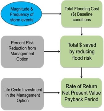
The Risk and Return on Investment Tool (STEP, 2019) is an available resource that can help determine priority areas for Aggregation. The tool assesses flood and erosion risks associated with extreme rainfall events to identify areas that are high risk. The tool quantifies potential damages through a financial assessment to evaluate risk-reduction achievable by stormwater management options. This helps users optimize their investment and make cost-effective decisions related to flood risk. More details are on the project website here: https://sustainabletechnologies.ca/home/urban-runoff-green-infrastructure/rroit/
Once the criteria have been selected, measures established and weightings advanced, and following a thorough vetting with the municipality and agencies (CA and others), the characterization and Issues datasets should be evaluated against the criteria and ranked accordingly. This largely GIS-based analysis will result in locations (map-based) across the community/watershed considered of high, medium, and low potential for aggregation. Due to the inherent understanding that aggregation would likely only have application to certain parts of the community/watershed, it is considered likely that only the high and possibly the medium areas would ever be advanced for assessment.
Step 3: Review Land Uses/Property Ownership
Approach:
A select number of priority areas (principally high/medium) will be derived through Steps 1 and 2. Within these areas, likely organized by drainage unit, there will be a mixture of land uses (public/private). For each selected (short-listed) priority area, it will be necessary to further discretize the land uses to determine the public and private composition, as well as the breakdown by property fabric (parcels). This latter task will allow for the distinction between the extent of runoff which can be managed at the public scale versus that which would require (and benefit from) private intervention. The property parcels will also provide an initial basic understanding of the orientation of properties (and specific uses) relative to where the problems are in the subject drainage unit, which may benefit from aggregation.
Information Sources:
Much of the required information will have been derived through steps 1 and 2; however additional information will be required on:
- Property fabric/ownership
- Public versus Private uses (more discrete than official plan or secondary plan level)
Outcomes:
The priority areas defined by drainage unit will be further mapped with more resolute information on uses (public or private) and also property fabric.
Step 4: Review Companion/Complementary Initiatives
Approach:
The initial steps (1, 2, and 3) will have used broad-based data to ultimately establish where the best locations are in the community to apply aggregation solutions based on the physical, social, and environmental character of the landscape, as well as the inherent drainage-based issues in the drainage system. Step 4 will collect more detailed information from public entities (upper and lower tier municipalities, the province, conservation authorities) specific to the priority areas. The intent of this step is to determine if there are priority areas which already have companion or potentially, complementary initiatives underway which may support (or potentially constrain) the application of aggregation. Without this information, future stages (specifically Stage II, Planning and Stage III, Design) will be at risk of either missing opportunities or potentially be working counter to other municipal/provincial plans and initiatives.
Information Sources:
The information for this step is expected to be sourced from various municipal departments, provincial agencies, and conservation authorities (Note: there may also be potential for some federal engagement where funding plans or federal initiatives overlap). The type of data include:
- Municipal capital plans
- Transportation/transit
- Roadway reconstruction/new roadways
- Transit infrastructure
- Water/wastewater/stormwater
- Transportation/transit
- New infrastructure
- Capacity upgrades
- Infrastructure renewal (lining/sealing, etcetera)
- Recreation
- Parks and trails
- Provincial and conservation authority plans
- Restoration
- Stewardship
Outcomes:
The companion initiatives by others will need to be spatially correlated the priority areas to allow for an understanding where infrastructure or system improvements/upgrades are already being planned by the public sector, which may influence (positively or negatively) the application of aggregation.
Step 5: Consultation
Approach:
As a community/watershed-based process, it is incumbent on the proponent (municipality and/or conservation authority) to conduct consultation. The term proponent has a direct relationship to the Class EA process and infers the party who takes on responsibility for the execution and financial aspects of the project. The consultation needs to be targeted and should include:
- General public
- Potentially affected landowners
- Stakeholders (agencies/NGO)
Given the unique requirements of each group, it is recommended that each be consulted differently.
In terms of the general public, it is unlikely that a traditional public information session would garner any interest or participation since the problems are too general and the study area too large. Therefore, alternate forms of communication should be considered including websites, on-line surveys, social media, webinars, community events, FAQ sheets, etc.
For the potentially affected landowners, this would be the first time they are approached, and the initial communication needs to be clear, balanced, and positive. Depending on the number of priority areas the Municipality and/or Conservation Authority may wish to host invited public meetings which will serve as information sessions. Alternatively (or in combination), an information package may be mailed to area owners in the priority areas and used to inform and solicit preliminary feedback to gauge early interest.
Lastly, the other stakeholders (agencies and NGO’s) not involved to-date will need to be contacted to determine if there is any interest and/or concerns with how the priority areas have been established and the process moving forward. This engagement is likely best achieved through more traditional mailout (digital) of material with a request for feedback.
Outcomes:
The feedback received from the respective groups may influence the number or priority level of the selected priority areas. There may also be certain insights offered through consultation which may influence how the assessments will take place in Stages II and III. It will be important to document this input for public transparency and future use in subsequent stages.
3.2 Stage II: Aggregation Planning (Meso)
Once the Municipality and Conservation Authority have established the location, extent and number of priority areas across their jurisdiction and a Capital Plan prepared for Study (planning and design) and implementation, the process shifts to its next stage which specifically focusses on studying the highest ranked priority areas to establish potential aggregation areas. A summary of the purpose and steps of Stage II is provided in Figure 6. As noted earlier, while aggregation is likely to be a supportable solution to address a specific drainage unit’s problems, it would not be considered an exclusive solution, hence there will be a requirement to fully evaluate the problem(s) and associated remediation alternatives, and systematically select the preferred solution(s). This process is already well-entrenched in Municipal practice through the Environmental Assessment Act, and specifically the MEA Class EA process (MCEA, 2015). By conducting a Class EA for the selected priority area(s), the Municipality, Stakeholders and Public can be assured that the principles of good infrastructure planning are applied, including:
- Consultation with affected parties early in and throughout the process, such that the planning process is a cooperative venture
- Consideration of a reasonable range of alternatives, both the functionally different “alternatives to” and the “alternative methods” of implementing the solution
- Identification and consideration of the effects of each alternative on all aspects of the environment
- Systematic evaluation of alternatives in terms of their advantages and disadvantages, to determine their net environmental effects
- Provision of clear and complete documentation of the planning process followed, to allow “traceability” of decision-making with respect to the project.
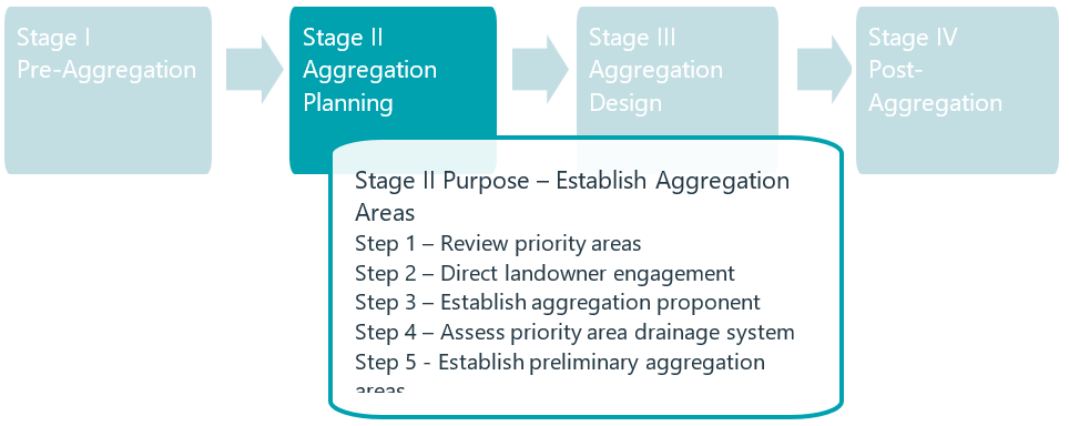
Figure 6. Summary of Stage II purpose and steps.
Using “Triple Bottom Line” factors, the problems, and associated solutions (including aggregation) can be assessed, and through integrated consultation with the Municipality, Agencies, directly affected Landowners and the Public, the preferred solution can be established accordingly. Inherent in this Planning Stage, will be direct engagement with those Landowners who may be willing to participate in an aggregation solution. The level of detail with respect to the form of aggregation will necessarily remain more high-level, with conceptual information only at this stage.
This is considered a critical stage in the process, since during this stage the questions whether aggregation is a supportable solution (when weighed against other more traditional solutions), will be answered and, most importantly, through the direct landowner engagement, it will be determined whether there is sufficient local interest to proceed to the next stage (Stage III – Design).
Step 1: Review Priority Areas
Approach:
This step can optionally occur at the end of Stage I or at the beginning of Stage II, the distinction being that at the end of Stage I, it would inform Municipal Capital Planning, whereas at the beginning of Stage II, some form of decision will already have been made specific to addressing the problems within the respective priority areas.
As an aggregation Planning process, this first step in this Stage inherently assumes that through the pending Class EA, aggregation will be selected as one of the potentially preferred solutions. While this essentially pre-supposes the process’s outcome, it is nevertheless an important step, since these Pre-Class EA steps (Steps 1 and 2) will provide central data on whether to proceed with an aggregation solution in the subject priority areas. It is possible that, based on the high-level First-Order economics (Subtask 2) or Direct Landowner Engagement (Step 2), it becomes evident that the subject priority area is not suitable or potentially of lower viability for aggregation, hence screening the subject priority area for near term application of aggregation.
Subtask 1: Select Highest-ranking Priority Area(s):
The highest-ranking priority area should be selected and the rationale for selection documented. Per Stage I, this is likely to be based on a combination of conducive site characteristics, appropriate land uses, potentially supportable ownership groups and suitably significant problems to be addressed.
Subtask 2: First-Order Economics:
In terms of first order economics for the selected priority areas, in locations serviced by a stormwater utility or rate, a calculation should be made of the potentially eligible properties in the priority area and the monthly/annual contributions made towards the utility, as an initial quantification of possible credit. The amount of credit and the conditions will likely vary from municipality to municipality, hence this will need to be considered accordingly. In addition to potential relief from a proportion of the stormwater rate charges, other possible economic benefits should be estimated at a high-level, recognizing that some may require monetization of non-market benefits (e.g., ecological enhancements due to improved water quality). Some potential first order economic considerations and estimates are:
- Reduced/eliminated sewer upgrades.
- Reduced/eliminated culvert upgrades.
- Reduced/eliminated treatment of clean runoff (I/I reduction).
- Reduced potable water use for non-potable users.
- Reduced erosion potential.
Improved base flows and water quality discharge are two non-monetary factors that should also be taken into consideration.
Due to the preliminary context at this stage, it is considered appropriate to use high-level estimation techniques, Class D according to CCA, 2012. Further, the economic benefits should be assigned to the various parties directly or indirectly benefitting from the investment in aggregation, including both public and private beneficiaries. This step will provide general guidance with respect to overall potential economics, subject to future detailed investigations and study.
Information Sources:
The priority areas will have been derived as part of Stage I, hence no additional information regarding these areas will be required unless of course Stage I is dated and in need of updating. In terms of the first order economics, it is suggested that information be secured on plans for capital investment within the drainage unit; again, much of this will have been collected during Stage I, hence the need to collect additional information will only be necessary if capital plans have been updated (municipal and provincial).
Outcomes:
The priority area will be identified and justified for selection, re-affirming the assumptions established during Stage I. Furthermore, the potential economics related to an aggregation solution will be estimated at a high-level, with due consideration of the proportion of stormwater charges averted, as well as other potential public and private benefits. As noted, this initial economic assessment should broadly consider as many potential benefits as possible, so as to not be limiting at the outset. This may involve estimation related to the monetization of non-capital items.
Step 2: Direct Landowner Engagement
Approach:
The initial contact with the potentially directly affected landowners will have been in Stage I. This second point of contact is expected to be much more detailed and comprehensive, as it will reflect a point in the infrastructure planning process where the municipality has identified a location (priority area) where problems exist, and also recognized an opportunity for public/private partnering to work towards solving the problems.
Depending on the size of the area and number of potential landowners, this consultation can take place at an invited meeting with technical representatives from the municipality providing details on:
- Priority area selection
- Nature of drainage problems and opportunities
- Outline of aggregation process
- First order economics
- Subsequent Steps
The private landowners would then be requested to provide input on the following:
- Existing drainage problems
- General plans for their lands (renewal/development)
- Water use for their property/business (non-potable)
- Interest
From this more focused engagement, the municipality will be able to understand whether there are any significant local constraints (current or planned) and whether there is sufficient interest in pursuing an aggregation solution.
To complement direct landowner engagement through meetings, resources can be provided to residents and business owners. For example, Toronto and Region Conservation Authority (TRCA) has created digital flood handbooks with information to help homeowners understand and prepare for flooding in flood vulnerable areas in TRCA’s jurisdiction (TRCA, 2022). Valuable flood related information is shared with property owners in the handout, including resources from the Intact Centre on Climate Adaptation. A similar approach to handouts could also be taken for industrial commercial areas.
Information Sources:
No additional information beyond landowner engagement described above will be required to execute this step. It should however be noted that the engagement needs to consider both the owners of the properties and the occupants of the operations, which in many circumstances may not be the same.
Outcomes:
Following the direct landowner engagement, the municipality will know whether or not there is sufficient support for aggregation, and also if there are any existing or emerging constraints which may affect the form/extent of aggregation in the subject priority area.
Step 3: Establish Aggregation Proponent
Approach:
Given that the municipality (with likely conservation authority support) has established the subject priority area as a priority for investment to address the associated drainage problems, and given that the screening process has acknowledged the potential application of an aggregation solution, it is considered appropriate for the municipality to continue its role as proponent, particularly given its inherent link to the subsequent MEA Class EA. Notwithstanding the role of the individual landowners, as contributors to the solution(s), and others like the conservation authority should be documented specific to this project, as it proceeds through the planning phase(s). Furthermore, other potential financial partners through companion programs (e.g., upper tier municipality infrastructure renewal) or funding/grant programs, should also be identified.
Information Sources:
Information will be required on potential funding and area infrastructure programs which may provide a revenue source. The timing and conditions of these programs will need to be clearly documented to determine any possible criteria related to the subject project.
Outcomes:
Initially the municipality is likely to be the proponent, hence the outcome of this step will be to confirm the municipality’s intent to continue to act as proponent. As well, other parties to the process, their role and potential involvement in subsequent aspects of the planning will be documented accordingly, including landowners, agencies, and funders.
Step 4: Assess Priority Area Drainage System (Class EA)
Approach:
This step is expected to constitute the formal MEA Class EA to address the problems in the subject priority area. The process is well documented, and details are available in the Municipal Class Environmental Assessment Manual (MEA, 2015). In brief, the key tasks include:
- Problem Definition
- Baseline Inventory
- Alternative Assessment
- Preferred Solution
Each primary task (depending on the schedule of work) will require consultation with regulators, stakeholders, the public and Indigenous Peoples.
As noted earlier, the problems in the subject priority area are likely to relate to historical/legacy urban runoff associated with both quantity and quality. As such, and in order to ensure full transparency of process, it will be necessary to evaluate potential solutions broadly with no bias towards aggregation. While highly likely that aggregation will be at least part of the preferred solution, it will be important to conduct an adequate and fulsome process which allows for this conclusion to be reached. The intent of this guideline document is not to repeat the well understood and broadly applied Class EA process (for this, readers are referred to MEA, 2015); rather, the objective is to outline how to plan, design and implement aggregation once (and if) the Class EA process has advanced this solution as part of the Preferred Solution for the problems in a priority area.
The text which follows describes the specifics associated with aggregation Planning.
Subtask 1: Conduct Triple Bottom Line Assessment
Contingent on aggregation being part of a preferred solution, further assessment will be required to advance the planning of its application in the subject priority area. To this point in the process, high-level assessments of the Social, Economic and Environmental factors will have taken place, therefore, as part of this subsequent subtask, it is proposed to develop additional enhanced information related to each category as follows:
Social Environment
- Property Fabric / Ownership / Use
- Site Constraints and Space Availability
- Access
- Aesthetics
- Long-range Redevelopment Proposals
Economics (Second Order)
- Updated Stormwater Rate Credit Potential
- Potential for Complementary Landowner Contributions (cash or in-kind)
- Access to other Funding Opportunities
- Overall Potential Budget
- Return-on-investment (ROI) requirements associated with the payback period
Natural / Physical Environment
- Watershed / Subwatershed Issues and Opportunities
- Site Specific Drainage Issues affecting Natural System Processes
- Physical Constraints (high-level)
- Soils
- Groundwater
- bedrock
The foregoing should be documented in maps, plans and a technical memorandum to serve as a basis of communication both within and external to the Class EA. The level of detail for the Class EA needs to be sufficient to support the selection of this alternative and its integration with subsequent planning processes.
Subtask 2: Define Preliminary Aggregation Areas (AA)
Within the priority areas, it is anticipated that there will be smaller areas with common characteristics which may constitute opportunities for aggregation; for the purpose of this methodology, these have been referred to as aggregation areas, since it is fully expected that not all of a priority area will be able to be aggregated.
Depending on the size of the priority area, there could be one or more aggregation areas. In terms of the planning for aggregation, it would be appropriate at this stage to consider the difference between aggregation areas (physically? socially? economically?) and use this information to rank them accordingly. As discussed earlier, the intent of this document is not to prescriptively describe how or what factors and criteria to consider when ranking these areas, as conditions and priorities will vary amongst communities and sub-communities.
Within each aggregation area, the opportunities and constraints to LID BMP implementation will vary, hence it is recommended at this stage to identify a long list of potential LID BMPs. See the LID BMP list in STEP’s LID planning and Design Guide (STEP, 2022) – Link to LID BMP list. From this long-list, various preliminary preferred applications will arise and should be considered for use in the subject aggregation area. This subtask should remain relative ‘low tech’ with basic calculations used for sizing and siting. Initial drainage plans, based on resolute contours (0.5 m or finer) and drainage infrastructure (sewers, overland routes, culverts, swales, ditches, etc.) should be prepared to support the preliminary selection and review of LID BMPs. In the absence of any detailed analytical modelling, various surrogate or proxy calculations can be used to support planning level decision-making. This process is expected to be preliminary and for the most part opportunistic, to depict private side works which potentially may work towards an aggregation solution for the subject aggregation area.
Once preliminary plans have been prepared for each aggregation area under consideration, the differences between the aggregation areas should be revisited to ensure the preference rankings established earlier, remain supportable, as there is potential to alter ranking based on the preferred LID BMPs in each aggregation area. It will be important to develop plans and documentation at this stage which are easily understood and relatively non-technical, as it will be used in subsequent subtasks to consult with area landowners and occupants.
Subtask 3: Landowner Engagement – Project Scoping Meeting / On-Site Meeting
Subtasks 1 and 2 will have resulted in a preferred or highest rank aggregation area for which to plan for aggregation. While earlier Landowner Engagement will have been general and higher level (to gauge interest and opportunities), this engagement is intended to be much more focused on the subject properties, their constraints, and opportunities, and through the presentation of the information package from Subtask 2, landowners and occupants will be able to more clearly envision the extent and nature of the works. Combined with Site Reconnaissance, this subtask will provide a clearer perspective on the opportunities which exist on the subject aggregation area landscape. Other aspects which can be considered at this time will include local internal problems (potentially faced by aggregation area landowners) which may previously have been unknown, and which may be synergistic to the overall objectives of aggregation.
Premised on the landowner/occupant feedback, the municipality will need to decide if there is currently sufficient support in the aggregation area and appropriate conditions to advance the priority area aggregation planning to the next Stage, specific to Design (Stage III). If there is insufficient support, or if conditions arise counter to the objectives of the aggregation process, the municipality may choose to select the next highest ranking aggregation area and proceed accordingly or modify the original aggregation area under consideration. If there is sufficient support and the conditions are aligned with aggregation implementation objectives, the municipality should proceed to Stage III Aggregation Design (Micro).
3.3 Stage III: Aggregation Design (Micro)
At this stage, the priority areas will have been established comprehensively across the municipality/ watershed, the broader scale Class EA will have evaluated alternatives to address the problems (drainage-based) in the priority area and concluded that aggregation is part of a preliminary preferred solution, and further refinement will have established the highest-ranking aggregation areas (within the larger priority areas) and confirmed landowner support and viable field conditions. Given the foregoing, the municipality can now enter the Design phase for the aggregation works (i.e., Stage III). A summary of the purpose and steps in Stage III are provided in
Figure 7. This Stage involves gathering actual field data (rather than reliance on earlier desktop information) and conducting more detailed and complex analyses, including hydrologic/hydraulic modelling. Further, premised on the foregoing data and analyses, additional screening of alternatives will take place leading to further Landowner Engagement. Premised on the feedback received, the conceptual alternatives are further detailed in preliminary designs to reflect the geometry and form of the subject work (LID BMP) on the various participating properties. Again, following further Landowner Engagement and premised on support, the preliminary designs of the LID BMPs are then advanced to detailed design in a staged manner (30, 60, 90% design), prior to permitting, approvals, tendering and construction.
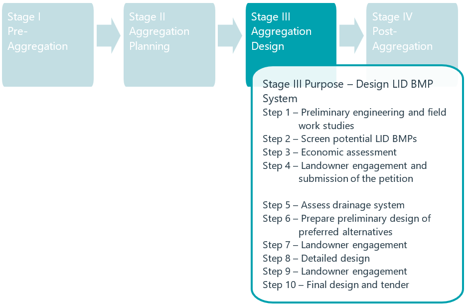
Figure 7. Summary of Stage III purpose and steps.
Step 1: Conduct Preliminary Engineering and Field Work Studies
Approach:
As noted, the process of assessment to this point will have been based predominantly on desktop information and limited/simplified analyses, often applying surrogates or proxies for decision making. In order to more confidently proceed in design, it is required to gather site specific data and add rigour to the analyses. Numerous guidelines exist which provide background to the nature of these studies (field and analytical); hence this section has not repeated the content contained in those guidance documents which include: “Grey to Green: Business & Multi-Residential Retrofit: Optimizing your Bottom Line through LID” (CVC, 2013).
Rather, key areas of study have been identified which will be considered at a minimum necessary to support the design process; these include:
Field Work
- Geotechnical
- Groundwater (seasonally varying)
- Bedrock proximity
- Soil properties
- Physical (infiltration)
- Chemical (contamination)
- Survey
- Surface features (trees, buildings, above-ground infrastructure)
- Subsurface (servicing and utilities)
- Environmental
- Water features
- Wood lots
- Other
- One Water Audit
- Non-potable uses
- Inflow and Infiltration
Analyses
- Hydrology
- Micro-drainage (overland/subsurface)
- Runoff patterns, volumes, rates
- Hydraulics
- Major/minor system performance
- Internal/external
Information Sources:
The procedures and data needs will vary, and more detailed and specific direction is provided in the references cited earlier. In short, information will be required on the various private parcels which can include legacy information (at the time of original design and construction), as well as current information related to any plans for redevelopment on the respective properties. The balance of the data will be gathered specifically through the field work to support design.
In terms of the One Water Audit, area industries or other (Industrial, Commercial, Institutional) ICI users will need to be audited for non-potable uses to determine potential synergies with respect to the aggregation process insofar as rainwater harvesting. Further, there may also be circumstances where private drainage (roof leaders, sump pumps, foundation drains etc.) adversely contributes to inflow/infiltration (I/I) to the sanitary system, which through an integrated stormwater management plan can be addressed through aggregation, and associated consultation with private landowners. Information on I/I would typically come from a separate focussed initiative which identifies possible sources and possible remedies.
Outcomes:
This step will provide the necessary database of information for preliminary and detailed design. The analytical tools (hydrology and hydraulics modelling) will provide the basis for assessing existing system performance and allow for the evaluation of various LID BMP retrofits.
Step 2: Screening and Preliminary Design of Potential LID Practices
Approach:
As part of the final planning step for Stage II, there will have been direct engagement, including on-site meetings with the landowners in the aggregation area. This will have allowed for a presentation of conceptual LID BMP retrofits. As part of the design process (Stage III), it is proposed to re-assess the earlier conceptual level LID BMP retrofits using the field data and analytical tools developed in Step 1. Again, numerous guidance documents exist which fulsomely detail the steps associated with design such as STEP’s Low Impact Development and Design Guide (STEP, 2020), and an E-learning Module on designing aggregated LID (STEP, 2021). It will be important at this stage to refine earlier details to reflect actual conditions and site hydrology/hydraulics. Numerous alternatives will be available; hence it will be important as part of this step to:
- Develop a long list of potential locations and LID BMP retrofit types
- Review the Objectives and Targets associated with the subject priority area and local aggregation area
- Assess technical functionality of LID BMP retrofits
- Establish preferred preliminary design/plan of LID BMP retrofits
Information Sources:
It is unlikely that additional information will be required at this stage since the majority of the data will have been collected as part of Step 1.
Outcomes:
This Step will lead to a refined set of preliminary LID BMP retrofits to be applied in the specific aggregation area. The Plan should depict the approximate limits of the LID BMP retrofits and also provide a quantum of size/volume to be managed.
Step 3: Conduct Economic Assessments (Third Order)
Approach:
At this Stage, more detailed information will be available with respect to the costs of implementation of the various LID BMP retrofits in the aggregation area. Given this level of detail, it is anticipated that a Class C (CCA, 2012) cost estimate can be prepared which will be based on actual capital items, albeit still at a preliminary design level. This economic assessment should also provide further detail and estimates with respect to other potential costs and benefits including:
- Land requirements
- Local infrastructure averted (private)
- External infrastructure averted (public)
- Secondary benefits
- Environmental
- Social
Earlier (Stage II, Step 4), a second order economic assessment will have established an updated amount for the stormwater credit (where a rate is in effect). For this step, this information should be confirmed and verified based on the higher order details associated with the design including land requirements and infrastructure averted.
Information Sources:
The majority of information should be available from earlier stages and steps to complete this Economic Assessment. The on-site and off-site infrastructure which through the implementation of the LID BMP retrofit will not be required or can be reduced (averted), will need to be defined and estimated accordingly. This information will be sourced from both the public and private sectors. In addition, the earlier Second Order Economic Assessment will have recognized possible secondary benefits/co-benefits, hence there will be a need to update and confirm these and gather any supplementary information to conduct this assessment.
Potential other funding sources (i.e., grants, funding programs) should also be identified to complete the full scan of funding opportunities.
Outcomes:
This will be the most complete and detailed Economic Assessment completed in the process to-date, providing details on the benefits (credits, costs averted, secondary) and costs (estimated capital). The costs will need to recognize a range of costs associated with a variety of LID BMPs, however, it is inherent that not all are likely to be accepted or be implementable, since following further screening and review with the participating Landowner group, there may be some pushback in certain locations of the aggregation area, which may bring forward the need for financial updates.
Step 4: Direct Landowner Engagement
Approach:
Similar to the previous Landowner Engagement towards the end of the Planning Stage (Stage II, Step 2), this engagement will need to present the various short-listed alternatives to the respective landowners who will be affected by the proposed works (LID BMP retrofits). Given the need for focused discussions, there may be some benefit at this stage to meet one-on-one or possibly with groups of landowners so as to use the time of all involved in the most efficient manner possible. The main items for discussion will include:
- Review of Short-Listed LID BMPs
- Feedback on locations, form, logistics, other
- Review Economic Assessment
The landowner feedback received will allow for further screening and refinement through subsequent steps.
Information Sources:
No new information, besides the feedback from landowner engagement cited above, will be expected during this step.
Outcomes:
The landowner information on the short-listed BMPs, locations, form, etc., as well as the Third Order Economics will provide the required information to complete the screening and establish the preliminary design.
Step 5: Assess Aggregation Area Drainage System
Approach:
The compiled feedback from all Property Owners in the aggregation area will need to be consolidated and considered in the process to finalize the form and location of the respective LID BMPs. Earlier, ‘Triple Bottom Line’ (TBL) assessment will have been carried out at a higher level (conceptual) to justify and validate the use of the aggregation approach. For this step, the decision has already been made to proceed to the aggregation approach, hence it will need to focus on the necessary evaluation of a short-list of techniques to result in a preferred suite of practices and locations within the aggregation area. This much more focused assessment (structured as a form of TBL), should consider:
- Economics
- Life cycle (including (O&M)
- Economies of Scale
- Updated/Refined Benefits to:
- Landowners
- Municipality (Upper/Lower Tier)
- Conservation Authority
- Others
- Environmental
- Level of Water Quality Benefits/Treatment (Retroactive)
- Thermal Benefits
- Water Budget/Quantity Benefits (Flow Rate, Runoff Volume)
- Social
- Site uses (compatibility)/Logistics
- Enhancements/Aesthetics
Based on this review, further assessment of the alternatives (form, size, location, etc.) can be conducted to optimize the plan for LID BMP retrofits in the selected aggregation area.
Information Sources:
Again, the majority of information will be available from Steps 1, 2, 3, and 4 to be able to update, refine and assess the plans for LID BMP retrofits.
Outcomes:
This Step will require formal documentation to trace the decision-making process related to the short-listing through to a preferred plan. The subsequent step will provide details specific to the preliminary engineering design to support the next stage of Landowner Engagement and subsequent detailed design.
Step 6: Prepare Preliminary Design of Preferred Alternatives
Approach:
The execution of Steps 1 to 5 will have resulted in a preferred plan of LID BMP retrofits within the aggregation area. The intent of this step will be to add additional preliminary engineering design detail to the respective works (plan, profile, details, geometry, spatial requirements, treatment, etc.). Additional data may be required in terms of local survey, local infrastructure (site), utilities, vegetation, appurtenances, plans for expansion, etc. This information will be used to update and refine previous plan versions of the works for subsequent review with the directly affected property owners, prior to detailed design. Construction costs will also be updated at this stage, refining the previous Class C cost estimate.
Information Sources:
As noted, given the stage of design, all site-based constraints need to be defined on plans which may influence the vertical or horizontal geometry of any of the LID BMP retrofits, including: utilities, services, appurtenances and plans for expansion/alteration of the sites under consideration. Further, depending on the detail available from earlier topographic surveys, additional survey may be required to fill gaps accordingly.
Outcomes:
Preliminary designs of proposed (preferred) LID BMP retrofits within the aggregation area. This will constitute plans, profiles, and details.
Step 7: Direct Landowner Engagement
Approach:
The previous (likely one-on-one) engagement with the aggregation area landowners and occupants will have presented optional LID BMP retrofits and offered recommendations on proposed works. Premised on the feedback from the individual property owners regarding their sites, and the compatibility of the proposed works, Step 6 will have developed more detailed and absolute plans of the recommended works. This Step will, hence, involve consultation with the aggregation area landowners to review the preliminary designs, as well as the updated economics (construction costs) prior to initiating detailed design. In the event any aspect of the preliminary design is in conflict with the local site plans or infrastructure, it will be incumbent on the municipality to update its plans and refine accordingly, essentially re-doing Steps 6 and 7.
Information Sources:
None besides the feedback from landowner engagement cited above, will be expected during this step.
Outcomes:
It will be important at this stage to secure support from the landowners on the plans for LID BMP retrofits on their properties. It will also be vital to initiate the process of developing legal agreements between the municipality and landowners for:
- Cost-sharing
- Access (easements)
- Operations and Maintenance
- Stormwater Credits
By way of background, the Drainage Act is considered particularly advantageous in this regard, as the Act provides for cost sharing, access, easements, and future maintenance. This approach also ensures that benefits and responsibilities are specified and allocated equitably, which includes not only the municipality (which is typically the case) but also the private landowners and other beneficiaries. Depending on the preferred mechanisms (Drainage Act or other), the municipality will need to make appropriate arrangement for the above components, prior to detailed design.
Step 8: Detailed Design Approach:
Once the Preliminary Design is approved and fully vetted by the landowner and occupant groups and the legal agreements in place (see Steps 6 and 7), the municipality can confidently proceed to Detailed Design. Again, there may be some gaps in information which will require supplemental field work and investigation. As part of this Step, the previous detailed hydrologic and hydraulic modelling will need to be updated to validate anticipated performance (quantity/quality) of the detailed design version of the system of LID BMP retrofits.
The Detailed Design process is well documented and will not be repeated herein; however, in brief, this will involve producing designs at a 30, 60, 90% stage and include:
- Plans
- Profiles
- Staging/Access
- Erosion & Sediment Controls
- Details
- Utility Plans
- Landscaping
- Specifications
- Form of Tender
- Engineering’s Estimate
- Permit Applications
Information Sources:
As per the previous steps, the Detailed Design may require supplemental field work (soil tests, utility plans, topography) to fill gaps and potential additional details from the directly affected landowners related to their on-site infrastructure, building, plans.
Outcomes:
Following review with municipal staff, regulators, and landowners (Step 9), the Detailed Design(s) of LID BMP retrofits for the aggregation area landowners will be comprised of:
- Drawing Set
- Tender
- Permit Applications
- Supporting Design Brief
Step 9: Direct Landowner Engagement Approach:
These final points of contact (following each stage of Detailed Design delivery 30, 60, 90%) will allow for feedback on various elements of the design with the landowners (and users of the property – if different) as it evolves. Items such as staging areas, use conflicts, time of year/time of day operational requirements, etc., will be discussed to ensure no conflicts with the ultimate plans of the affected landowners during implementation.
Information Sources:
All supplemental information at this stage is expected to be directly sourced from the landowners in the aggregation area.
Outcomes:
Necessary feedback to update and refine the Detailed Design plans for the LID BMP retrofits in the aggregation area.
Step 10: Finalize Design and Tender Approach:
The previous 30, 60, 90% designs and supporting information will be updated and finalized based on the feedback from the landowners as well as others (municipal departments, Conservation Authority, Upper Tier municipalities, etc.). The Engineer’s Estimate will also be updated to a Class B cost estimate based on refined and detailed quantity take offs. The Ministry of Environment Conservation and Parks (MECP) has modernized Ontario’s Environmental Compliance Approval (ECA) process for low-risk municipal sewage works (i.e., LID practices) by initiating a Consolidated Linear Infrastructure permissions approach in 2020. It allows for pre-authorized work to be completed as per the conditions set out in the ECA without the need for a separate approval. This requires that the Plans and Designs meet criteria specific to the ECA.
Information Sources:
None.
Outcomes:
Final Contract Tender (Plans and Specifications) and Permits for preferred LID BMP retrofits. Depending on the nature of the works and the proposed approach, the municipality may choose to tender the works for the whole aggregation area as part of a single contract or divide into multiple contracts depending on various factors, including: type of LID BMP retrofit, location, property ownership or other local restrictions.
3.4 Stage IV: Post Aggregation Implementation, Monitoring and O&M
Stages I, II and III address the Pre-Planning, Planning and Design aspects of the LID BMPs through aggregation in aggregation areas within priority areas. This process will result in drainage management infrastructure (retrofits) being designed on Private lands which will ultimately be built, monitored, and then operated and maintained accordingly (see Figure 8). This final stage addresses these core requirements in order to establish functional and sustainable infrastructure which manages the historical impacts on drainage and the environment due to urbanization.
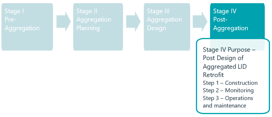
Figure 8. Summary of Stage IV purpose and steps.
Step 1: Construction (Implementation)
As noted earlier, several factors will need to be considered as part of the implementation of LID BMP retrofits, including the provision of legal agreements and cost sharing provisions. Furthermore, the execution of the construction contract(s) will need to be carefully linked to local landowner/user operations, so as to not conflict (or minimize) with on-site/local operations. This may involve staged or multiple contracts.
During construction, it will be necessary to have standard construction oversight, including input from specialists such as geotechnical engineers, landscape architects, and others. Project manager should consult with these experts on an as-needed basis to ensure the works are being properly constructed to the specifications and provisions of the detailed design contract.
Step 2: Monitoring
Monitoring of the performance of infrastructure is a standard requirement of the MEA Class EA process and often a direct requirement of permitting and approvals. The objective of monitoring is to ensure that the subject infrastructure (LID BMP retrofits) functions as per design, specific to the anticipated benefits for water quality and water quantity. In order to be most meaningful, monitoring data need to be registered to ‘baseline’ conditions, hence where possible, information on the quantity and quality of runoff under existing conditions (pre-construction) should be collected with a view to establishing an understanding of how the existing system functions (without retroactive SWM). Following the implementation of a system of LID BMP retrofits in an aggregation area, the network should be monitored for key quantity and quality parameters. Area meteorological data, if unavailable from standard sources, should also be collected as this would represent the driving function for the drainage system (rainfall, snow melt or both).
Numerous publications exist which provide insights into the approach to monitoring including equipment, protocols and reporting requirements. Refer to:
- Low Impact Development Stormwater Management Practice Inspection and Maintenance Guide, (TRCA, 2016) and,
- CVC Stormwater Management and Low Impact Development Monitoring and Performance Assessment Guide, (CVC, 2015) and,
- STEP LID Planning and Design Guide BMP Fact Sheets, (STEP, 2022).
Given that some of the monitoring may be required as a condition of approvals/permitting, it will be important to tailor the design of the monitoring program and reporting in a sufficiently comprehensive manner to fulfil these needs.
Step 3: Operations and Maintenance
Depending on the form/type of LID BMP retrofit, the scope of Operations and Maintenance will vary. Numerous documents are available which detail the type, frequency and scope of Operations and Maintenance activity by LID BMP type (TRCA, 2016 and CVC, 2015).
Given the anticipated need for financial and human resources, and potentially specialized equipment, it will be necessary as part of the early stages (no later than Stage III), to have established a framework for cost sharing specific to the required Operations and Maintenance activities. Some activities can be seamlessly integrated into normal site operations (i.e., debris clean out, grass cutting) whereas other activities would be expected to be more onerous and costly which may require specialist intervention. An Operations and Maintenance Plan should be prepared as part of the Final Detailed Design and Permitting submission which outlines the details associated with the ultimate short and long-term operations and maintenance of the subject infrastructure, and associated responsibilities.
4 Conclusions/Next Steps
The impacts due to urbanization on stormwater runoff without proper management can lead to flood risks, degraded water quality, erosion of watercourses and altered water budget/cycle. Traditional end of pipe stormwater management, while effective in newer greenfield developments, tends to be more problematic in existing urbanized areas which constitute the majority of development in municipalities. There are limited incentives however to apply stormwater management retroactively to these existing urban lands, resulting in virtually no uptake of voluntary, private property retrofits through stormwater utilities, largely due to long payback periods. Stormwater management retrofits (i.e., applying stormwater management where there is none today) can achieve substantial benefits including improved water quality and reductions in stormwater runoff (peaks and volume). Stormwater management retrofits can be applied in the public realm (i.e., road right-of-way, municipal properties). However, in areas without stormwater management, there typically are not sufficient suitable public lands available for end-of-pipe retrofits. In established urban areas, existing infrastructure already crowds the road right-of-way, leaving little space for stormwater management retrofits. It can also be challenging and costly to acquire private land for dedicated stormwater management retrofits.
It is noteworthy that co-benefits of retroactively applied Low Impact Development Best Management Practices (LID BMPs) are rarely fully valued, hence the non-market benefits while complex to determine can be important to overall triple bottom line valuation (CVC, 2018b; CVC, 2021). As a result, this document has outlined an alternative approach referred to as “aggregation” which involves collectives of multiple private (and sometimes public) properties which can then take advantage of economies of scale, multi-party cost-sharing and technical efficiencies, to optimize the cost and functional benefits of stormwater management at source through LID BMPs (CVC, 2017; CVC, 2018a).
This report details a four-stage methodology associated with the planning, design, implementation, operations and maintenance, and financing of an aggregation approach to stormwater management. This Guidance Document provides municipalities and their partners/stakeholders with an approach to conducting a top-down methodology to addressing runoff problems (quality and quantity), which considers aggregation as a viable approach to stormwater management, building on the principles of the Environmental Assessment Act, [ref. Municipal Engineer’s Association (MEA) Class Environmental Assessment (EA) (MCEA, 2015)]. Furthermore, the Drainage Act (and its procedural steps) has been identified as a potential instrument by which multiple property owners can collaborate to establish a drainage system, through the aggregation process.
Additional background information and discussion on the rationale for communal retrofits is available at https://sustainabletechnologies.ca/home/urban-runoff-green-infrastructure/aggregated-communal-approaches-to-gi-implementation/. You can also consult Figure 9 for a summary of CVC’s reports on aggregating private properties for LID retrofits.
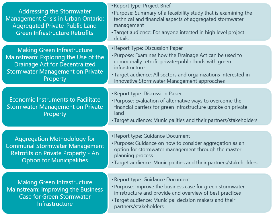
Figure 9. Summary of CVC’s communal green infrastructure deliverables.
As with any new approach or methodology, as advocated herein, it will be necessary to trial the approach through pilot studies, and also with multiple partners (municipalities) to develop an understanding of what works and what does not work, as well. This feedback will allow for constant improvement over time and facilitate hopefully better uptake and success going forward. It is suggested that a database of application be set up much like Engineers Canada through its PIEVC Protocol, which similarly has developed and subsequently applied a new approach to risk based assessment of climate change influenced infrastructure planning and design. As the database grows in content and application examples, the aggregation methodology can be updated accordingly. Furthermore, CVC has included a Case Study of the Southdown area in Mississauga, which has generated some lessons learned as related to the aggregation approach. While the Southdown Case study has not followed the methodology outlined herein on a one-to-one basis, it has shed light on some considerations for future users, in order maximize success. See Southdown Case Study: Aggregating Private Properties for Communal Stormwater Management Retrofits for reference.
5 Process Flow Charts
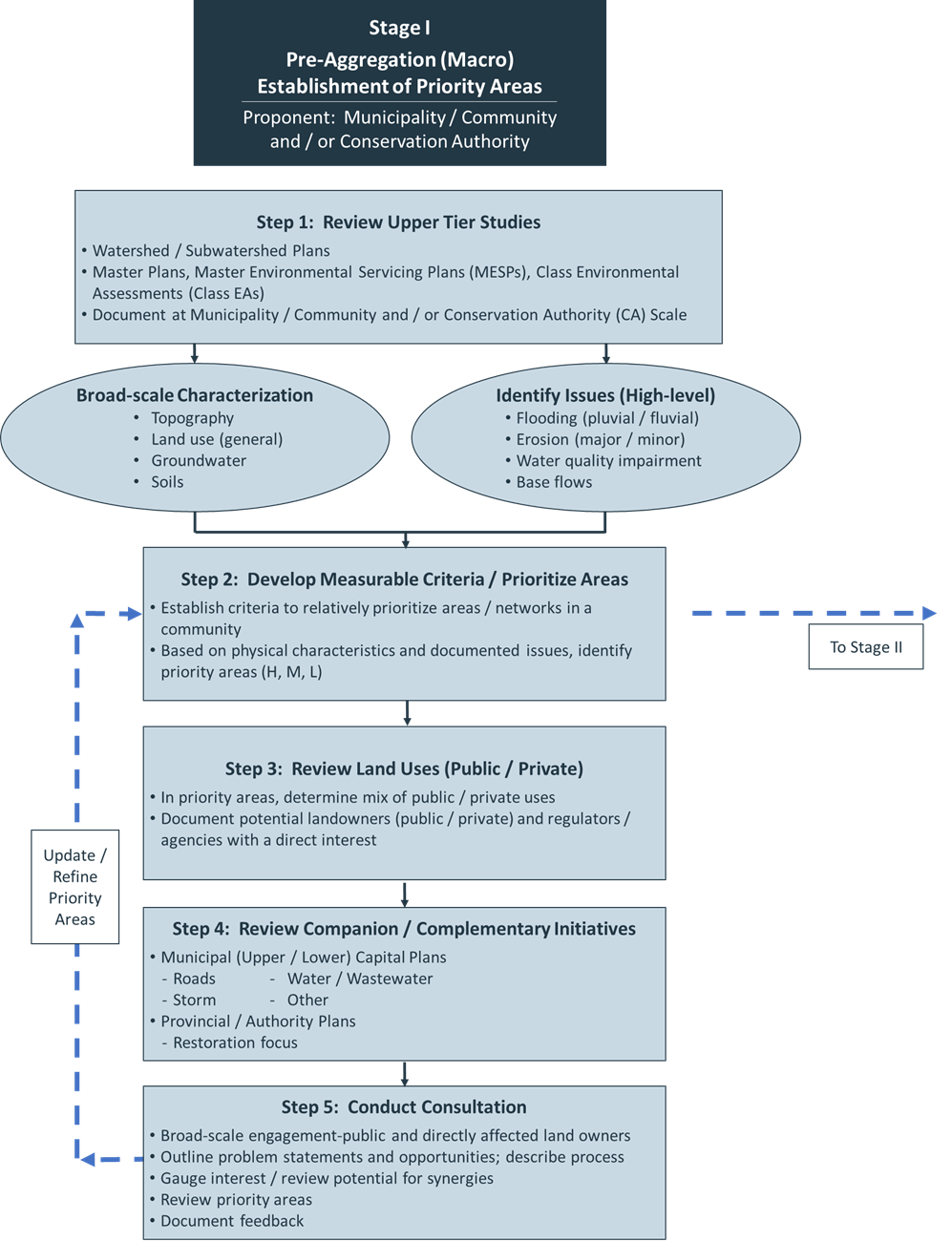
Figure 10: Stage I flow chart.
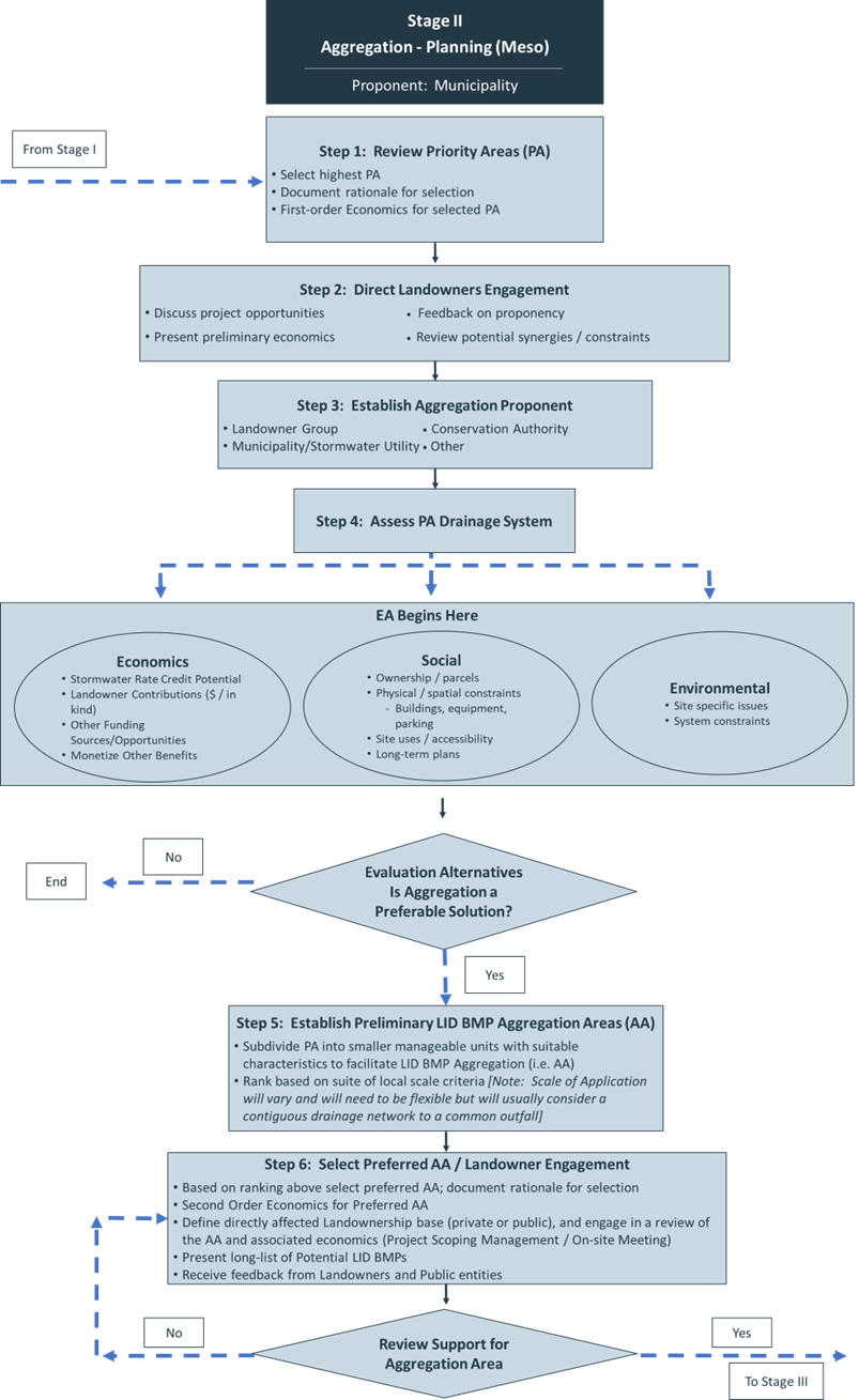
Figure 11. Stage II flow chart.
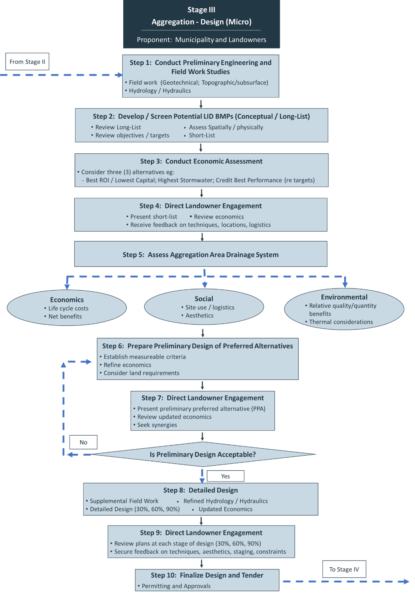
Figure 12. Stage III flow chart.
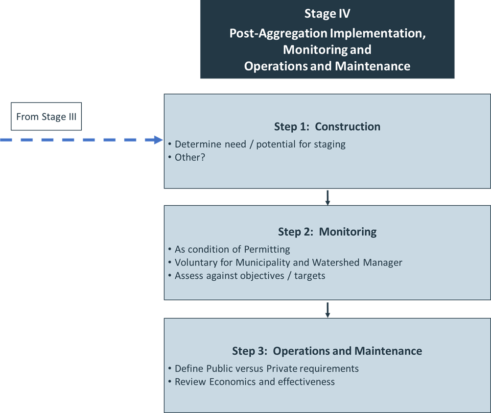
Figure 13. Stage IV flow chart.
6 References
Canadian Construction Association (CCA). 2012. Guide to Cost Predictability in Construction: an Analysis of Issues Affecting the Accuracy of Construction Cost Estimates. https://www.cca-acc.com/wp-content/uploads/2016/07/GuideCostPredictability.pdf.
Chandler, K.R. and N.A. Chappell. 2008. Influence of individual oak (Quercus robur) trees on saturated hydraulic conductivity. Forest Ecology and Management. 256: 1222-1229. doi: 10.1016/j.foreco.2008.06.033
City of Windsor. 2017. The Mayor’s 8 Point Plan. https://www.citywindsor.ca/residents/Construction/Environmental-Assessments-Master-Plans/Documents/The_Mayors_8_Point_Plan.pdf
Credit Valley Conservation (CVC). 2015. CVC Stormwater Management and Low Impact Development Monitoring and Performance Assessment Guide. Credit Valley Conservation, Mississauga, Ontario. https://cvc.ca/wp-content/uploads//2021/07/Monitoring_Guide_Final.pdf
Credit Valley Conservation (CVC). 2017. Making Green Infrastructure Mainstream: Exploring the Use of the Drainage Act for Decentralized Stormwater Management on Private Property. Credit Valley Conservation, Mississauga, Ontario. https://sustainabletechnologies.ca/app/uploads/2019/03/Making-GI-mainstream.pdf
Credit Valley Conservation (CVC). 2018a. The Drainage Act as a Tool to Facilitate the Aggregation and Wide-Scale Implementation of Green, Low Impact Drainage Infrastructure on Private Property. Credit Valley Conservation, Mississauga, Ontario. https://sustainabletechnologies.ca/app/uploads/2020/11/Position-Paper-Drainage-Act-and-GI.pdf
Credit Valley Conservation (CVC). 2018b. Economic Instruments to Facilitate Stormwater Management on Private Property. Credit Valley Conservation, Mississauga, Ontario. https://sustainabletechnologies.ca/app/uploads/2019/03/Econ-Instruments-for-SWM-on-Private-Property.pdf
Credit Valley Conservation (CVC). 2019. Clearview Creek Feasibility Study. Credit Valley Conservation, Mississauga, Ontario.
Credit Valley Conservation (CVC). 2020. Addressing the Stormwater Management Crisis in Urban Ontario: Aggregated Private-Public Land Green Infrastructure Retrofits. Credit Valley Conservation, Mississauga, Ontario. https://sustainabletechnologies.ca/app/uploads/2021/05/Aggregated-Retrofits-Project-Synopsis_STEP-Case-Study-Temp_altV4.pdf
Credit Valley Conservation (CVC). 2021. Making Green Infrastructure Mainstream: Improving the Business Case for Green Stormwater Infrastructure. Credit Valley Conservation, Mississauga, Ontario. https://sustainabletechnologies.ca/app/uploads/2021/06/CVC_Making_Green_Infrastructure_Mainstream_English_May_2021_Final.pdf
Drainage Act, Revised Statutes of Ontario (1990, c. C-D.17). https://www.ontario.ca/laws/statute/90d17
Environmental Commissioner of Ontario (ECO). 2016. Urban Stormwater Fees: How to Pay for What We Need. https://media.assets.eco.on.ca/web/2016/11/Urban-StormwaterFees.pdf.
Ontario Ministry of Agriculture, Food and Rural Affairs, 2018. A Guide for Engineers Working Under the Drainage Act in Ontario. OMAFRA publication 852.
Ministry of Environment and Energy (MOEE). 1993. Subwatershed Planning. https://archive.org/details/subwatershedplan00ontauoft/mode/2up
Ministry of Environment Conservation and Parks (MECP). 2020. Environmental Compliance Approval for a Municipal Stormwater Management System. https://prod-environmental-registry.s3.amazonaws.com/2020-07/Draft%20Storm%20LI%20ECA%20Template%20July%202020_0.pdf
Municipal Engineer’s Association (MEA). 2015. 2015 Version of Municipal Class Environmental Assessment. https://municipalclassea.ca/manual/mcea-index.html
O’Brien, Delbert, 2010. Easements in Drainage.
Easements in Drainage, by Delbert O’Brien, 2010 (uoguelph.ca)
Philadelphia Water Department. 2022. FY2022 Stormwater Grant Awardees. https://water.phila.gov/pool/files/february-2022-stormwater-grant-awardees.pdf
Sustainable Technologies Evaluation Program (STEP). 2022. LID SWM Planning and Design Guide. https://wiki.sustainabletechnologies.ca/wiki/Main_Page
Sustainable Technologies Evaluation Program (STEP). 2021. Steps for Designing Communal Low Impact Development Stormwater Retrofits E-learning Course. https://sustainabletechnologies.ca/events/steps-for-designing-communal-low-impact-development-stormwater-retrofits-e-learning-course/
Toronto and Region Conservation Authority (TRCA). 2016. Low Impact Development Stormwater Management Practice Inspection and Maintenance Guide. Prepared by the Sustainable Technologies Evaluation Program. Vaughan, Ontario. https://sustainabletechnologies.ca/app/uploads/2016/08/LID-IM-Guide-2016-1.pdf
Toronto and Region Conservation Authority (TRCA). 2022. Residents Living in TRCA’s Flood Vulnerable Neighbourhoods. Residents Living in TRCA’s Flood Vulnerable Neighbourhoods – Toronto and Region Conservation Authority (TRCA)
Appendix A: Glossary of Terms
Table A-A 1. Glossary of Terms.
| Terms | Meaning / Definition |
| 30%, 60%, 90% Design | These reflect various stages of the design process (either preliminary or detailed) intended to reflect increasing levels of detail leading to a final deliverable. |
| Aggregation | Process by which multiple private properties are combined (or aggregated) to provide fiscal and functional benefits for the application of Low Impact Development Best Management Practices (LID BMPs). |
| Aggregation Areas | These represent smaller units (sub to priority areas) which would constitute the scale or resolution by which properties would be aggregated into a local functional unit. The actual scale can be flexible; however, it can relate to two (2) properties up to any number along a street or within a drainage network. |
| Case Study | This is considered an investigation which applies an approach or strategy as an example or proof of concept undertaking. |
| Co-benefits | Positive effects of LID BMPs that are not directly related to traditional stormwater management goals. Co-benefits include air pollution removal, urban heat island reduction, habitat creation, energy savings, and greenhouse gas reduction. |
| Economies-of-scale | Refers to the financial or cost related benefits when a project becomes larger with more participants who can share in the unitary reduction in individual costs when compared to smaller site-specific projects. |
| Economics (First Order) | At the earliest stage of planning (Stage I), proponents will be aware at a high-level of some, but not all, of the potential benefits and costs of aggregation. In particular, the co-benefits (non-market) will only be definable at a conceptual level, hence making any sort of prediction of benefits in financial terms, would be unlikely to support formative decision making. Furthermore, the costing of any infrastructure capital works at this stage should be conducted at a coarse Class D Level per CCA, 2012. |
| Economics (Second Order) | At the second stage of planning (Stage II), proponents will be more aware of the potential benefits and costs of aggregation. In particular, the co-benefits (non-market) will likely be more definable beyond the conceptual level associated with Stage I. These benefits, in financial terms, would be useful to support decision making. Furthermore, the costing of any infrastructure capital works at this stage should be conducted at a slightly more refined Class C Level per CCA, 2012. |
| Economics (Third Order) | During the Design stage (Stage III), the designers will conduct more detailed field work and associated preliminary and then detailed design of the aggregation LID BMPs. At this stage material quantities and scope of work will become better defined and as a result the construction cost estimate will become similarly more resolute. Other co-benefits may also come into more focus which will allow the proponent and the landowners a higher degree of certainty related to ultimate economic performance of the proposed aggregation design. The costing of any infrastructure capital works at this stage should be conducted at a more refined Class C Level per CCA, 2012. |
| Feasibility Study | Similar to a Case Study, a Feasibility study investigates to ability of a concept or strategy or approach to be able to meet core objectives associated with a hypothesis. |
| Green Infrastructure | Green Infrastructure describes a strategically planned and delivered network of natural and semi-natural elements that collectively deliver a wide range of ecosystem, social and economic services to help reduce dependence on grey infrastructure and to address environmental resilience and climate change |
| Greenfield Development | Describes land that is typically in a natural and or agricultural state which has been slated for urban development through a municipality’s Official plan. |
| Life Cycle Costs | Represents the total investment associated with both capital and operations and maintenance of infrastructure over its designated lifetime. The lifetime of works will vary depending on the form/type. |
| Low Impact Development Best Management Practices (LID BMPs) | These would be stormwater management measures typically implemented at or near the source of runoff from buildings, parking areas, and other impervious surfaces, designed to capture, infiltrate, and treat runoff prior to its discharge into the communal drainage system, comprised of sewers, ditches and roadways. |
| Master Drainage Plan | A municipally prepared document which considers a set of solutions for a broad geography either for the whole of a municipality or a subset depending on the problem definition. If conducted formally under the Class EA process it will establish a level of approval for the subsequent planning of works in the community. |
| Monitoring | Refers to post‑construction activities to ensure that the constructed works are functioning per the intended design and overall objectives. |
| Municipal Class Environmental Assessment | Established under the Environmental Assessment Act, a process which allows municipalities to systematically assess a “class” of works as they would have a range of predictable impacts and solutions. The various works are defined under a set of schedules (A, A+, B and C) of increasing complexity. |
| Networks | A municipal drainage system which typically discharges to a single outlet to an open system like a creek or river. A network is comprised of urban uses and would typically have a major / minor system constituting storm sewers and ditches. |
| Non-Market Benefits | Non-market benefits are goods which are not bought and sold in a market, so their monetary value must be estimated by other means. Air purification, habitat creation, urban heat island mitigation, and water quality improvements are common benefits generated by LID BMPs and which are considered important to account for in cost-benefit analyses. Economists have developed a suite of methods for giving nonmarket goods a monetary valuation, including Total Economic Value (TEV), ecosystem valuation, contingent valuation, hedonic pricing, contingent choice, and benefit transfer. |
| Payback Period | Payback period is the amount of time over which the cost of the initial investment is recovered through cost savings or new revenues. It is estimated as the initial investment divided by the average monthly or annual net revenue or cost savings. A longer payback period indicates a lower return and greater risk and uncertainty associated with an investment. |
| Priority Areas | These would constitute the broader-scale locations within subwatersheds and watersheds which have a high level of importance (priority) for some form of remediation through appropriate stormwater management. Typically, these areas would exhibit issues associated with flooding, erosion, water quality, contamination, etc. |
| Proponent | This relates to the party or group of parties who would be responsible for initiating and managing a project. |
| Quality Benefits | These would be deemed the positive outcomes from the implementation of LID BMPs in an aggregated setting to realize improved runoff water quality and reduced thermal enrichment (heating). |
| Quantity Benefits | Similar to Quality Benefits, these would constitute the anticipated outcomes from the application of LID BMPs to address impacts associated with water budget / water balance, and erosion, and to a lesser degree, flooding. |
| Return on Investment (ROI) | This would constitute a financial term used to describe the economic benefits associated with implementing a project as related to the total amount invested at the outset and over time based on operations and maintenance costs. |
| Stormwater Credits | As part of stormwater utilities, some municipalities consider a program by which homeowners are compensated (credited) with relief from a portion of a stormwater charge by implementing lot level practices voluntarily. |
| Synergies | This refers to the opportunities for local landowners and businesses who have planned on-lot (building or infrastructure) improvements to consider combining these efforts to be coincident or complementary to aggregation works. An example relates to rainwater harvesting for use in an industrial application which provides benefits to reduced cost for treated water while also reducing off site discharge of runoff through local capture. |
| Thermal Considerations | Urban runoff typically is influenced by heating through thermal enrichment (contact of stormwater with hot surfaces-such as pavement in the summer) which adds thermal energy to receiving water bodies. |
| Treatment Train | This reflects the process whereby stormwater runoff is treated by multiple forms of stormwater management including combinations of practices associated with source, conveyance, and end-of-pipe treatment. |
| Urban Heat Island | Urban areas are covered with surfaces that retain heat (concrete, brick, and asphalt) causing urban temperatures to be higher than surrounding rural or natural areas. Also, because they have little vegetation, they do not benefit from shade or the cooling effects of evapotranspiration. |
Publication Information
This guidance document was prepared by Credit Valley Conservation through the Sustainable Technologies Evaluation Program and Wood Environment & Infrastructure Solutions, a Division of Wood Canada Limited.
Citation: Credit Valley Conservation (CVC) and Wood Canada. 2022. Aggregation Methodology for Communal Stormwater Management Retrofits on Private Property. Credit Valley Conservation, Mississauga, Ontario.
Documents prepared by the Sustainable Technologies Evaluation Program (STEP) are available at www.sustainabletechnologies.ca. For more information about this or other STEP publications, please contact:
| Phil James, P.Eng. Senior Manager, Integrated Water Management Credit Valley Conservation Authority 1255 Old Derry Road Mississauga, Ontario E-mail: rohan.hakimi@cvc.ca | Kyle Vander Linden Senior Advisor, Guidance, Policy and Strategic Partnerships, Integrated Water Management Credit Valley Conservation Authority 1255 Old Derry Road Mississauga, Ontario E-mail: kyle.vanderlinden@cvc.ca |
STEP
The water component of the Sustainable Technologies Evaluation Program (STEP) is a partnership between Toronto and Region Conservation Authority (TRCA), Credit Valley Conservation and Lake Simcoe Region Conservation Authority. STEP supports broader implementation of sustainable technologies and practices within a Canadian context by:
- Carrying out research, monitoring and evaluation of clean water and low carbon technologies;
- Assessing technology implementation barriers and opportunities;
- Developing supporting tools, guidelines and policies;
- Delivering education and training programs;
- Advocating for effective sustainable technologies; and
- Collaborating with academic and industry partners through our Living Labs and other initiatives.
Technologies evaluated under STEP are not limited to physical devices or products; they may also include preventative measures, implementation protocols, alternative urban site designs, and other innovative practices that help create more sustainable and livable communities.
Acknowledgements
Funding support for this document was generously provided by:
- Federation of Canadian Municipalities
- City of Mississauga
- Region of Peel
We would also like to thank everyone who contributed to this guide by providing data, technical review, and expert advice on behalf of the following organizations:
- John Kuntze (K. Smart Associates Ltd.)
- Neal Morris (K. Smart Associates Ltd.)
- Mike Fortin (Mike Fortin Associates)
- City of Mississauga
Notice
While support was received from the above noted individuals and agencies to prepare this document, such support does not indicate their endorsement of its contents. Although every reasonable effort has been made to ensure the integrity of the contents of this document, the supporting individuals and agencies do not make any warranty or representation, expressed or implied, with respect to the accuracy or completeness of the information contained herein. Mention of trade names or commercial products does not constitute endorsement or recommendation of those products. The purpose of this communication is to provide general information of a legal nature. It does not contain a full analysis of the law nor does it constitute an opinion on the points of law discussed.